Weather Alert in Alaska
Special Weather Statement issued September 5 at 4:25AM AKDT by NWS Anchorage AK
AREAS AFFECTED: Kuskokwim Delta Coast and Nunivak Island
DESCRIPTION: A strong low pressure system in the Bering Sea sends its front eastward to the Kuskokwim Delta Coast by this afternoon. Southeast winds will pick up through the day today and become strong and gusty by tonight. Winds gusts of up to 50 mph at times are likely in communities along the northern Kuskokwim Bay Coast tonight through Saturday morning before slowly diminishing Saturday afternoon. Locations impacted include Kongiganak, Kwigillingok, and Kipnuk. Along with the strong push of southeasterly winds, water levels will also increase with peak water levels occurring late Saturday morning. Water levels are expected to peak at 1 to 2 feet above the normal highest tide line. While significant coastal flooding is not expected, low-lying areas could fill up with water, especially around Kipnuk and Kwigillingok. Higher wave heights are also likely in the coastal waters of the Kuskokwim Delta and near the coast with 4 to 8 foot waves likely. Wave heights will peak Saturday morning and slowly subside through Sunday morning. Higher waves breaking along the coast could cause some localized areas of beach erosion.
INSTRUCTION: N/A
Want more detail? Get the Complete 7 Day and Night Detailed Forecast!
Current U.S. National Radar--Current
The Current National Weather Radar is shown below with a UTC Time (subtract 5 hours from UTC to get Eastern Time).

National Weather Forecast--Current
The Current National Weather Forecast and National Weather Map are shown below.

National Weather Forecast for Tomorrow
Tomorrow National Weather Forecast and Tomorrow National Weather Map are show below.

North America Water Vapor (Moisture)
This map shows recent moisture content over North America. Bright and colored areas show high moisture (ie, clouds); brown indicates very little moisture present; black indicates no moisture.

Weather Topic: What is Graupel?
Home - Education - Precipitation - Graupel
 Next Topic: Hail
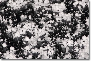
Graupel is a form of precipitation that is created by atmospheric conditions
which cause supercooled water droplets to contact snow crystals and freeze to
their surface.
Sometimes known as soft hail or snow pellets, graupel is delicate and easily
destroyed by touch. Whereas hail usually falls during severe weather, graupel
doesn't require such conditions to form, and can form in mild precipitation
similar to situations which produce snowfall.
Next Topic: Hail
Weather Topic: What are Hole Punch Clouds?
Home - Education - Cloud Types - Hole Punch Clouds
 Next Topic: Mammatus Clouds
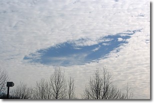
A hole punch cloud is an unusual occurrence when a disk-shaped
hole appears in a cirrostratus, cirrocumulus, or altocumulus cloud.
When part of the cloud forms ice crystals, water droplets in the surrounding area
of the cloud evaporate. The effect of this process produces a large elliptical
gap in the cloud. The hole punch cloud formation is rare, but it is not specific
to any geographic area.
Other names which have been used to describe this phenomena include fallstreak hole,
skypunch, and cloud hole.
Next Topic: Mammatus Clouds
Current conditions powered by WeatherAPI.com


