Weather Alert in Washington
Flood Warning issued March 14 at 1:16PM PDT until March 15 at 6:00AM PDT by NWS Portland OR
AREAS AFFECTED: Cowlitz, WA
DESCRIPTION: ...The Flood Warning continues for the following rivers in Washington... Cowlitz River at Kelso affecting Cowlitz County. ...The Flood Warning is cancelled for the following rivers in Washington...Oregon... Cowlitz River at Castle Rock affecting Cowlitz County. Wilson River near Tillamook affecting Tillamook County. * WHAT...Minor flooding is occurring and minor flooding is forecast. * WHERE...Cowlitz River at Kelso. * WHEN...Until tomorrow morning. * IMPACTS...Above 21.5 feet, flooding of several low lying and secondary roads begins, including the Cowlitz Gardens neighborhood, along with flooding of pasture and lowland upstream of Kelso. * ADDITIONAL DETAILS... - At 12:58 PM PDT Saturday the stage was 22.4 feet. - Bankfull stage is 18.0 feet. - Recent Activity...The maximum river stage in the 24 hours ending at 12:58 PM PDT Saturday was 23.5 feet. - Forecast...The river will oscillate above flood stage with a maximum value of 22.3 feet this afternoon. It will fall below flood stage late this evening. - Flood stage is 21.5 feet. - http://www.weather.gov/safety/flood
INSTRUCTION: Be especially cautious at night when it is harder to recognize the dangers of flooding. Motorists should not attempt to drive around barricades or drive through flooded areas. Turn around, don't drown when encountering flooded roads. Most flood deaths occur in vehicles. Additional information is available at www.weather.gov. The next statement will be issued this afternoon at 230 PM PDT.
Want more detail? Get the Complete 7 Day and Night Detailed Forecast!
Current U.S. National Radar--Current
The Current National Weather Radar is shown below with a UTC Time (subtract 5 hours from UTC to get Eastern Time).

National Weather Forecast--Current
The Current National Weather Forecast and National Weather Map are shown below.

National Weather Forecast for Tomorrow
Tomorrow National Weather Forecast and Tomorrow National Weather Map are show below.

North America Water Vapor (Moisture)
This map shows recent moisture content over North America. Bright and colored areas show high moisture (ie, clouds); brown indicates very little moisture present; black indicates no moisture.

Weather Topic: What are Wall Clouds?
Home - Education - Cloud Types - Wall Clouds
 Next Topic: Altocumulus Clouds
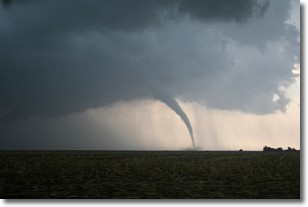
A wall cloud forms underneath the base of a cumulonimbus cloud,
and can be a hotbed for deadly tornadoes.
Wall clouds are formed by air flowing into the cumulonimbus clouds, which can
result in the wall cloud descending from the base of the cumulonimbus cloud, or
rising fractus clouds which join to the base of the storm cloud as the wall cloud
takes shape.
Wall clouds can be very large, and in the Northern Hemisphere they generally
form at the southern edge of cumulonimbus clouds.
Next Topic: Altocumulus Clouds
Weather Topic: What are Altostratus Clouds?
Home - Education - Cloud Types - Altostratus Clouds
 Next Topic: Cirrocumulus Clouds
Altostratus clouds form at mid to high-level altitudes
(between 2 and 7 km) and are created by a warm, stable air mass which causes
water vapor
to condense as it rise through the atmosphere. Usually altostratus clouds are
featureless sheets characterized by a uniform color.
In some cases, wind punching through the cloud formation may give it a waved
appearance, called altostratus undulatus. Altostratus clouds
are commonly seen with other cloud formations accompanying them.
Next Topic: Cirrocumulus Clouds
Current conditions powered by WeatherAPI.com


