Weather Alert in Alabama
Flood Warning issued March 14 at 9:22AM CDT until March 15 at 9:08PM CDT by NWS Birmingham AL
AREAS AFFECTED: Greene, AL; Hale, AL; Marengo, AL
DESCRIPTION: ...The Flood Warning continues for the following rivers in Alabama... Black Warrior River At Selden Lock and Dam affecting Marengo, Hale and Greene Counties. .Flooding continues on the Black Warrior River and a flood warning remains in effect. * WHAT...Minor flooding is occurring and minor flooding is forecast. * WHERE...Black Warrior River at Selden Lock and Dam. * WHEN...Until late tomorrow evening. * IMPACTS...At 90.0 feet, Pasture and wood lands begin to flood. Livestock should be moved to higher ground at stages above 90 feet. * ADDITIONAL DETAILS... - At 9:00 AM CDT Saturday the stage was 91.8 feet. - Recent Activity...The maximum river stage in the 24 hours ending at 9:00 AM CDT Saturday was 91.9 feet. - Forecast...The river is expected to rise to a crest of 92.0 feet this afternoon. It will then fall below flood stage late tomorrow morning. - Flood stage is 90.0 feet.
INSTRUCTION: Turn around, don't drown when encountering flooded roads. Most flood deaths occur in vehicles. && The next statement will be issued late tonight, or sooner if conditions warrant.
Want more detail? Get the Complete 7 Day and Night Detailed Forecast!
Current U.S. National Radar--Current
The Current National Weather Radar is shown below with a UTC Time (subtract 5 hours from UTC to get Eastern Time).

National Weather Forecast--Current
The Current National Weather Forecast and National Weather Map are shown below.

National Weather Forecast for Tomorrow
Tomorrow National Weather Forecast and Tomorrow National Weather Map are show below.

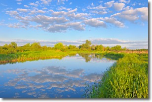
North America Water Vapor (Moisture)
This map shows recent moisture content over North America. Bright and colored areas show high moisture (ie, clouds); brown indicates very little moisture present; black indicates no moisture.

Weather Topic: What are Stratocumulus Clouds?
Home - Education - Cloud Types - Stratocumulus Clouds
 Next Topic: Stratus Clouds
Stratocumulus clouds are similar to altocumulus clouds in their
fluffy appearance, but have a slightly darker shade due to their additional mass.
A good way to distinguish the two cloud types is to hold your hand out and measure
the size of an individual cloud; if it is the size of your thumb it is generally
an altocumulus cloud, if it is the size of your hand it is generally a
stratocumulus cloud.
It is uncommon for stratocumulus clouds to produce precipitation, but if they do
it is usually a light rain or snow.
Next Topic: Stratus Clouds
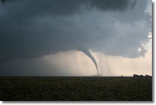
Weather Topic: What are Wall Clouds?
Home - Education - Cloud Types - Wall Clouds
 Next Topic: Altocumulus Clouds
A wall cloud forms underneath the base of a cumulonimbus cloud,
and can be a hotbed for deadly tornadoes.
Wall clouds are formed by air flowing into the cumulonimbus clouds, which can
result in the wall cloud descending from the base of the cumulonimbus cloud, or
rising fractus clouds which join to the base of the storm cloud as the wall cloud
takes shape.
Wall clouds can be very large, and in the Northern Hemisphere they generally
form at the southern edge of cumulonimbus clouds.
Next Topic: Altocumulus Clouds
Current conditions powered by WeatherAPI.com


