Weather Alert in Alaska
High Wind Warning issued August 27 at 1:11PM AKDT until August 28 at 10:00PM AKDT by NWS Anchorage AK
AREAS AFFECTED: Anchorage Hillside / Eagle River
DESCRIPTION: * WHAT...Southeast winds 35 to 45 mph with gusts up to 70 mph expected. * WHERE...Anchorage Hillside / Eagle River. * WHEN...From 2 AM to 10 PM AKDT Thursday. * IMPACTS...High winds may move loose debris, damage property, and cause power outages. Trees are still fully leafed, and will be particularly vulnerable to damage in strong winds. Travel could be difficult, especially for high profile vehicles. * ADDITIONAL DETAILS...A strong frontal system moving into Southcentral will bring widespread wind gusts ranging from 50 to 70 mph to the Anchorage Hillside beginning early Thursday morning. The strongest winds are expected to peak near the middle of the day on Thursday. Winds will then slowly weaken through Thursday evening and diminish by early Friday morning.
INSTRUCTION: People are urged to secure loose objects that could be blown around or damaged by the wind. Prepare for the possibility of widespread power outages. Use caution if you must drive.
Want more detail? Get the Complete 7 Day and Night Detailed Forecast!
Current U.S. National Radar--Current
The Current National Weather Radar is shown below with a UTC Time (subtract 5 hours from UTC to get Eastern Time).

National Weather Forecast--Current
The Current National Weather Forecast and National Weather Map are shown below.

National Weather Forecast for Tomorrow
Tomorrow National Weather Forecast and Tomorrow National Weather Map are show below.

North America Water Vapor (Moisture)
This map shows recent moisture content over North America. Bright and colored areas show high moisture (ie, clouds); brown indicates very little moisture present; black indicates no moisture.

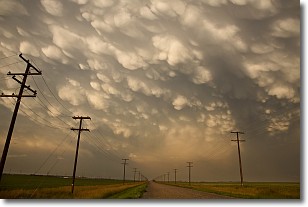
Weather Topic: What are Mammatus Clouds?
Home - Education - Cloud Types - Mammatus Clouds
 Next Topic: Nimbostratus Clouds
A mammatus cloud is a cloud with a unique feature which resembles
a web of pouches hanging along the base of the cloud.
In the United States, mammatus clouds tend to form in the warmer months, commonly
in the Midwest and eastern regions.
While they usually form at the bottom of a cumulonimbis cloud, they can also form
under altostratus, altocumulus, stratocumulus, and cirrus clouds. Mammatus clouds
warn that severe weather is close.
Next Topic: Nimbostratus Clouds
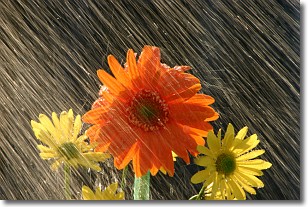
Weather Topic: What is Precipitation?
Home - Education - Precipitation - Precipitation
 Next Topic: Rain
Precipitation can refer to many different forms of water that
may fall from clouds. Precipitation occurs after a cloud has become saturated to
the point where its water particles are more dense than the air below the cloud.
In most cases, precipitation will reach the ground, but it is not uncommon for
precipitation to evaporate before it reaches the earth's surface.
When precipitation evaporates before it contacts the ground it is called Virga.
Graupel, hail, sleet, rain, drizzle, and snow are forms of precipitation, but fog
and mist are not considered precipitation because the water vapor which
constitutes them isn't dense enough to fall to the ground.
Next Topic: Rain
Current conditions powered by WeatherAPI.com


