Weather Alert in Wisconsin
Winter Weather Advisory issued March 14 at 11:04PM CDT until March 16 at 4:00PM CDT by NWS Milwaukee/Sullivan WI
AREAS AFFECTED: Ozaukee
DESCRIPTION: * WHAT...For the first Winter Weather Advisory, mixed precipitation. Additional snow accumulations up to one inch and ice accumulations around a light glaze. Winds gusting as high as 40 MPH. For the second Winter Weather Advisory, moderate snow expected. Total snow accumulations between 3 and 5 inches. Winds gusting as high as 45 MPH leading to some blowing and drifting snow. * WHERE...Ozaukee County. * WHEN...For the first Winter Weather Advisory, until 10 AM CDT Sunday. For the second Winter Weather Advisory, from 10 PM Sunday to 4 PM CDT Monday. * IMPACTS...Plan on slippery road conditions. Areas of blowing snow could significantly reduce visibility. The hazardous conditions could impact the Monday morning and evening commutes. Gusty winds could bring down tree branches.
INSTRUCTION: Persons are urged to stay indoors until conditions improve. If you must go outside, dress in layers. Several layers of clothes will keep you warmer than a single heavy coat. Cover exposed skin to reduce your risk of frostbite or hypothermia. Gloves, a scarf, and a hat will keep you from losing your body heat. Be prepared for slippery roads. Slow down and use caution while driving. If you are going outside, watch your first few steps taken on stairs, sidewalks, and driveways. These surfaces could be icy and slippery, increasing your risk of a fall and injury. Slow down and use caution while traveling. The latest road conditions for the state you are calling from can be obtained by calling 5 1 1.
Want more detail? Get the Complete 7 Day and Night Detailed Forecast!
Current U.S. National Radar--Current
The Current National Weather Radar is shown below with a UTC Time (subtract 5 hours from UTC to get Eastern Time).

National Weather Forecast--Current
The Current National Weather Forecast and National Weather Map are shown below.

National Weather Forecast for Tomorrow
Tomorrow National Weather Forecast and Tomorrow National Weather Map are show below.

North America Water Vapor (Moisture)
This map shows recent moisture content over North America. Bright and colored areas show high moisture (ie, clouds); brown indicates very little moisture present; black indicates no moisture.

Weather Topic: What are Altostratus Clouds?
Home - Education - Cloud Types - Altostratus Clouds
 Next Topic: Cirrocumulus Clouds
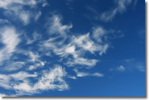
Altostratus clouds form at mid to high-level altitudes
(between 2 and 7 km) and are created by a warm, stable air mass which causes
water vapor
to condense as it rise through the atmosphere. Usually altostratus clouds are
featureless sheets characterized by a uniform color.
In some cases, wind punching through the cloud formation may give it a waved
appearance, called altostratus undulatus. Altostratus clouds
are commonly seen with other cloud formations accompanying them.
Next Topic: Cirrocumulus Clouds
Weather Topic: What are Cirrostratus Clouds?
Home - Education - Cloud Types - Cirrostratus Clouds
 Next Topic: Cirrus Clouds
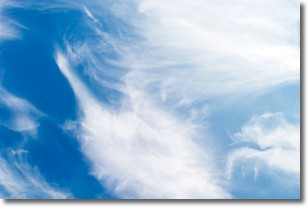
Cirrostratus clouds are high, thin clouds that form above
20,000 feet and are made mostly of ice crystals. They sometimes look like giant
feathers, horse tails, or curls of hair in the sky.
These clouds are pushed by the jet stream and can move at high speeds reaching
100 mph.
What do they indicate?
They indicate that a precipitation is likely within 24 hours.
Next Topic: Cirrus Clouds
Current conditions powered by WeatherAPI.com


