Weather Alert in Indiana
Flood Warning issued July 2 at 8:54PM EDT until July 3 at 4:24PM EDT by NWS Indianapolis IN
AREAS AFFECTED: Daviess, IN; Gibson, IN; Knox, IN; Pike, IN
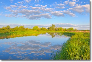
DESCRIPTION: ...The Flood Warning continues for the following river and locations in Indiana... White River at Hazleton and Petersburg. ...The Flood Warning is extended for the following river and location in Indiana... White River at Edwardsport. .Recent rainfall of 3 to 7 inches across the area over the past few days has created lowland flooding along the White River near Petersburg and Hazleton, where the crest has arrived. River flooding should end before the weekend arrives. * WHAT...Minor flooding is occurring and minor flooding is forecast. * WHERE...White River at Petersburg. * WHEN...Until tomorrow afternoon. * IMPACTS...At 16.0 feet, Flooding affects agricultural lands. * ADDITIONAL DETAILS... - At 8:30 PM EDT Wednesday /7:30 PM CDT Wednesday/ the stage was 16.4 feet. - Recent Activity...The maximum river stage in the 24 hours ending at 8:30 PM EDT Wednesday /7:30 PM CDT Wednesday/ was 16.5 feet. - Forecast...The river is expected to fall below flood stage late tonight and continue falling and remain below flood stage. - Flood stage is 16.0 feet. - http://www.weather.gov/safety/flood
INSTRUCTION: Be especially cautious at night when it is harder to recognize the dangers of flooding. Flooding is occurring or is imminent. Most flood related deaths occur in automobiles. Do not attempt to cross water covered bridges, dips, or low water crossings. Never try to cross a flowing stream, even a small one, on foot. To escape rising water find another route over higher ground. Additional information is available at www.weather.gov/ind. The next statement should be issued this evening by around 1100 PM EDT /1000 PM CDT/.
Want more detail? Get the Complete 7 Day and Night Detailed Forecast!
Current U.S. National Radar--Current
The Current National Weather Radar is shown below with a UTC Time (subtract 5 hours from UTC to get Eastern Time).

National Weather Forecast--Current
The Current National Weather Forecast and National Weather Map are shown below.

National Weather Forecast for Tomorrow
Tomorrow National Weather Forecast and Tomorrow National Weather Map are show below.

North America Water Vapor (Moisture)
This map shows recent moisture content over North America. Bright and colored areas show high moisture (ie, clouds); brown indicates very little moisture present; black indicates no moisture.

Weather Topic: What are Stratocumulus Clouds?
Home - Education - Cloud Types - Stratocumulus Clouds
 Next Topic: Stratus Clouds
Stratocumulus clouds are similar to altocumulus clouds in their
fluffy appearance, but have a slightly darker shade due to their additional mass.
A good way to distinguish the two cloud types is to hold your hand out and measure
the size of an individual cloud; if it is the size of your thumb it is generally
an altocumulus cloud, if it is the size of your hand it is generally a
stratocumulus cloud.
It is uncommon for stratocumulus clouds to produce precipitation, but if they do
it is usually a light rain or snow.
Next Topic: Stratus Clouds
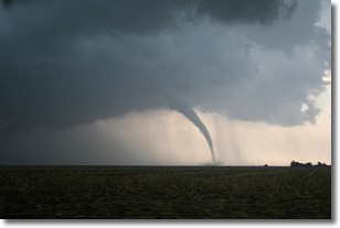
Weather Topic: What are Wall Clouds?
Home - Education - Cloud Types - Wall Clouds
 Next Topic: Altocumulus Clouds
A wall cloud forms underneath the base of a cumulonimbus cloud,
and can be a hotbed for deadly tornadoes.
Wall clouds are formed by air flowing into the cumulonimbus clouds, which can
result in the wall cloud descending from the base of the cumulonimbus cloud, or
rising fractus clouds which join to the base of the storm cloud as the wall cloud
takes shape.
Wall clouds can be very large, and in the Northern Hemisphere they generally
form at the southern edge of cumulonimbus clouds.
Next Topic: Altocumulus Clouds
Current conditions powered by WeatherAPI.com


