Weather Alert in Maine
Special Weather Statement issued August 22 at 8:39AM EDT by NWS Gray ME
AREAS AFFECTED: Interior York; Central Interior Cumberland; Androscoggin; Kennebec; Interior Waldo; Coastal York; Coastal Cumberland; Sagadahoc; Lincoln; Knox; Coastal Waldo; Interior Cumberland Highlands; Strafford; Eastern Hillsborough; Interior Rockingham; Coastal Rockingham
DESCRIPTION: A very dry air mass and breezy conditions will combine with dead and dry fuels such as grass, leaves, and twigs to create the potential for uncontrolled fire spread across the coastal plain of Maine and southeast New Hampshire today. This afternoon, relative humidity values will decrease to low levels between 25 to 30 R.H. %. At the same time, north to northeast| winds between 10 to 15 mph with frequent gusts to 20 mph will continue to dry fuels and increase fire spread potential. Near the coast, a sea breeze will develop this afternoon with southeast winds gusting to 20 mph. Wind gusts are expected to diminish later this evening with increasing relative humidity values. Extra caution should be taken to prevent wildfires. Always consult with fire officials before engaging in any open burning activities and comply with all applicable laws and regulations. Never leave an open fire unattended and always extinguish campfires completely before leaving.
INSTRUCTION: N/A
Want more detail? Get the Complete 7 Day and Night Detailed Forecast!
Current U.S. National Radar--Current
The Current National Weather Radar is shown below with a UTC Time (subtract 5 hours from UTC to get Eastern Time).

National Weather Forecast--Current
The Current National Weather Forecast and National Weather Map are shown below.

National Weather Forecast for Tomorrow
Tomorrow National Weather Forecast and Tomorrow National Weather Map are show below.

North America Water Vapor (Moisture)
This map shows recent moisture content over North America. Bright and colored areas show high moisture (ie, clouds); brown indicates very little moisture present; black indicates no moisture.

Weather Topic: What is Rain?
Home - Education - Precipitation - Rain
 Next Topic: Shelf Clouds
Precipitation in the form of water droplets is called rain.
Rain generally has a tendency to fall with less intensity over a greater period
of time, and when rainfall is more severe it is usually less sustained.
Rain is the most common form of precipitation and happens with greater frequency
depending on the season and regional influences. Cities have been shown to have
an observable effect on rainfall, due to an effect called the urban heat island.
Compared to upwind, monthly rainfall between twenty and forty miles downwind of
cities is 30% greater.
Next Topic: Shelf Clouds
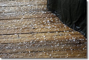
Weather Topic: What is Sleet?
Home - Education - Precipitation - Sleet
 Next Topic: Snow
Sleet is a form of precipitation in which small ice pellets are the primary
components. These ice pellets are smaller and more translucent than hailstones,
and harder than graupel. Sleet is caused by specific atmospheric conditions and
therefore typically doesn't last for extended periods of time.
The condition which leads to sleet formation requires a warmer body of air to be
wedged in between two sub-freezing bodies of air. When snow falls through a warmer
layer of air it melts, and as it falls through the next sub-freezing body of air
it freezes again, forming ice pellets known as sleet. In some cases, water
droplets don't have time to freeze before reaching the surface and the result is
freezing rain.
Next Topic: Snow
Current conditions powered by WeatherAPI.com


