Weather Alert in Wisconsin
Blizzard Warning issued March 14 at 9:19PM CDT until March 16 at 7:00AM CDT by NWS La Crosse WI
AREAS AFFECTED: Taylor; Clark; Buffalo; Trempealeau; Jackson
DESCRIPTION: ...DANGEROUS WINTER STORM TO IMPACT THE REGION THROUGH MONDAY MORNING... .A dangerous and potentially historic winter storm will impact the region through Monday morning. Snow rates north of Interstate 90 will increase throughout the overnight. By early Sunday morning snowfall rates of 2 to 4 inches per hour are likely across portions of northern Clark and Taylor Counties. Mixed precipitation is likely near I-90 Sunday morning where freezing rain accumulations of one to three tenths of an inch of ice is likely. By Sunday afternoon, much of the area will switchover to snow with wind gusts increasing to 35 to 55 mph. This will result in widespread visibilities reductions to 1/4 mile or less at times where the Blizzard Warning is in effect. Storm total snow accumulations will likely approach all-time records in north-central Wisconsin with 18 to 36 inches of snow expected north of Interstate 94. Travel will be impossible for much of the area throughout the storm. Any travel should be reserved for emergencies only. Power outages and tree damage will be possible with the combination of heavy snow, ice, and increasing winds on Sunday. * WHAT...For the Winter Storm Warning, heavy mixed precipitation expected with heavy snow expected north Interstate 94. For the Blizzard Warning, blizzard conditions expected with winds gusting as high as 45 mph. Storm total snow accumulations south of Interstate 94 between 10 and 18 inches and ice accumulations around a light glaze. Storm total snow accumulations north of Interstate 94 of 18 to 36 inches. * WHERE...Clark, Taylor, Buffalo, Jackson, and Trempealeau Counties. * WHEN...For the Winter Storm Warning, until 10 AM CDT Sunday. For the Blizzard Warning, from 10 AM Sunday to 7 AM CDT Monday. * IMPACTS...Travel could be very difficult to impossible. Areas of blowing snow could significantly reduce visibility. The hazardous conditions could impact the Monday morning commute. Gusty winds could bring down tree branches.
INSTRUCTION: If you must travel, keep an extra flashlight, food, and water in your vehicle in case of an emergency. Visit 511wi.gov for road conditions. Travel should be restricted to emergencies only. If you must travel, have a winter survival kit with you. If you get stranded, stay with your vehicle. In Minnesota, visit 511mn.org for road conditions. In Wisconsin, visit 511wi.gov for road conditions.
Want more detail? Get the Complete 7 Day and Night Detailed Forecast!
Current U.S. National Radar--Current
The Current National Weather Radar is shown below with a UTC Time (subtract 5 hours from UTC to get Eastern Time).

National Weather Forecast--Current
The Current National Weather Forecast and National Weather Map are shown below.

National Weather Forecast for Tomorrow
Tomorrow National Weather Forecast and Tomorrow National Weather Map are show below.

North America Water Vapor (Moisture)
This map shows recent moisture content over North America. Bright and colored areas show high moisture (ie, clouds); brown indicates very little moisture present; black indicates no moisture.

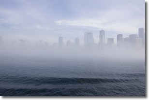
Weather Topic: What is Fog?
Home - Education - Cloud Types - Fog
 Next Topic: Fractus Clouds
Fog is technically a type of stratus cloud, which lies along the
ground and obscures visibility.
It is usually created when humidity in the air condenses into tiny water droplets.
Because of this, some places are more prone to foggy weather, such as regions
close to a body of water.
Fog is similar to mist; both are the appearance of water droplets suspended in
the air, but fog is the term applied to the condition when visibility is less than 1 km.
Next Topic: Fractus Clouds
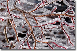
Weather Topic: What is Freezing Rain?
Home - Education - Precipitation - Freezing Rain
 Next Topic: Graupel
Freezing rain is a condition where precipitation which has fallen in the form of
water droplets reaches temperatures which are below freezing and freezes upon
coming into contact
with surface objects. The result of this precipitation is a glaze of ice which
can be damaging to plants and man-made structures. A severe onset of freezing
rain which results in a very thick glaze of ice is known as an ice storm.
Next Topic: Graupel
Current conditions powered by WeatherAPI.com


