Weather Alert in Minnesota
Winter Storm Warning issued March 14 at 9:19PM CDT until March 15 at 10:00AM CDT by NWS La Crosse WI
AREAS AFFECTED: Wabasha; Dodge; Olmsted; Winona; Mower; Fillmore; Houston
DESCRIPTION: ...DANGEROUS WINTER STORM TO IMPACT THE REGION THROUGH MONDAY MORNING... .A dangerous and potentially historic winter storm will impact the region through Monday morning. Snow rates north of Interstate 90 will increase throughout the overnight. By early Sunday morning snowfall rates of 2 to 4 inches per hour are likely across portions of northern Clark and Taylor Counties. Mixed precipitation is likely near I-90 Sunday morning where freezing rain accumulations of one to three tenths of an inch of ice is likely. By Sunday afternoon, much of the area will switchover to snow with wind gusts increasing to 35 to 55 mph. This will result in widespread visibilities reductions to 1/4 mile or less at times where the Blizzard Warning is in effect. Storm total snow accumulations will likely approach all-time records in north-central Wisconsin with 18 to 36 inches of snow expected north of Interstate 94. Travel will be impossible for much of the area throughout the storm. Any travel should be reserved for emergencies only. Power outages and tree damage will be possible with the combination of heavy snow, ice, and increasing winds on Sunday. * WHAT...For the Winter Storm Warning, heavy mixed precipitation expected. Total ice accumulations up to two tenths of an inch. For the Blizzard Warning, blizzard conditions expected. Total snow accumulations between 6 and 13 inches. Winds gusting as high as 50 mph. * WHERE...A portion of southeast Minnesota. * WHEN...For the Winter Storm Warning, until 10 AM CDT Sunday. For the Blizzard Warning, from 10 AM Sunday to 7 AM CDT Monday. * IMPACTS...Travel could be very difficult. Widespread blowing snow could significantly reduce visibility. The hazardous conditions could impact the Monday morning commute. Strong winds could cause tree damage.
INSTRUCTION: If you must travel, keep an extra flashlight, food, and water in your vehicle in case of an emergency. Visit 511mn.org for road conditions. Travel should be restricted to emergencies only. If you must travel, have a winter survival kit with you. If you get stranded, stay with your vehicle. In Minnesota, visit 511mn.org for road conditions. In Wisconsin, visit 511wi.gov for road conditions.
Want more detail? Get the Complete 7 Day and Night Detailed Forecast!
Current U.S. National Radar--Current
The Current National Weather Radar is shown below with a UTC Time (subtract 5 hours from UTC to get Eastern Time).

National Weather Forecast--Current
The Current National Weather Forecast and National Weather Map are shown below.

National Weather Forecast for Tomorrow
Tomorrow National Weather Forecast and Tomorrow National Weather Map are show below.

North America Water Vapor (Moisture)
This map shows recent moisture content over North America. Bright and colored areas show high moisture (ie, clouds); brown indicates very little moisture present; black indicates no moisture.

Weather Topic: What is Sleet?
Home - Education - Precipitation - Sleet
 Next Topic: Snow
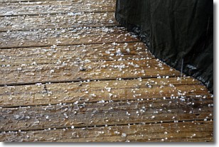
Sleet is a form of precipitation in which small ice pellets are the primary
components. These ice pellets are smaller and more translucent than hailstones,
and harder than graupel. Sleet is caused by specific atmospheric conditions and
therefore typically doesn't last for extended periods of time.
The condition which leads to sleet formation requires a warmer body of air to be
wedged in between two sub-freezing bodies of air. When snow falls through a warmer
layer of air it melts, and as it falls through the next sub-freezing body of air
it freezes again, forming ice pellets known as sleet. In some cases, water
droplets don't have time to freeze before reaching the surface and the result is
freezing rain.
Next Topic: Snow
Weather Topic: What are Stratocumulus Clouds?
Home - Education - Cloud Types - Stratocumulus Clouds
 Next Topic: Stratus Clouds
Stratocumulus clouds are similar to altocumulus clouds in their
fluffy appearance, but have a slightly darker shade due to their additional mass.
A good way to distinguish the two cloud types is to hold your hand out and measure
the size of an individual cloud; if it is the size of your thumb it is generally
an altocumulus cloud, if it is the size of your hand it is generally a
stratocumulus cloud.
It is uncommon for stratocumulus clouds to produce precipitation, but if they do
it is usually a light rain or snow.
Next Topic: Stratus Clouds
Current conditions powered by WeatherAPI.com


