Weather Alert in Michigan
Red Flag Warning issued April 28 at 9:00AM EDT until April 28 at 6:00PM EDT by NWS Gaylord MI
AREAS AFFECTED: Emmet; Leelanau; Antrim; Benzie; Grand Traverse; Kalkaska; Manistee; Wexford; Missaukee; Charlevoix
DESCRIPTION: ...Critical Fire Weather Conditions Today... .Stronger south winds with frequent gusts combine with a dry airmass today. South winds of 5 to 10 mph with frequent gusts up to 20 mph will become 10 to 15 mph with gusts up to 30 mph by early afternoon today. Humidity values will dip quickly late this morning, becoming 20% to 25% by early afternoon. These conditions will last through the mid and late afternoon hours. Winds continue to strengthen this evening, however moisture will begin to move in from the west. Sunny skies and mixing heights around 4kft will lead to unstable air today. NE lower will likely see the longest critical conditions, possibly lasting into the evening hours. The National Weather Service in Gaylord has issued a Red Flag Warning, which is in effect until 6 PM EDT this evening. * AFFECTED AREA...Fire weather zones 016, 020, 021, 025, 026, 027, 031, 032, 033, and 099. * WIND...South winds of 10 to 15 mph with frequent gusts up to 30 mph. Winds will strengthen this evening. * HUMIDITY...Minimum relative humidity 23% to 28%. The lowest values will be over interior areas. * THUNDERSTORMS...Chances for thunderstorms tonight. * HIGHEST THREAT...Highest threat areas will be interior locations. * IMPACTS...any fires that develop will likely spread rapidly. Outdoor burning is not recommended.
INSTRUCTION: A Red Flag Warning means that critical fire weather conditions are either occurring now....or will shortly. A combination of strong winds...low relative humidity...and warm temperatures can contribute to extreme fire behavior.
Want more detail? Get the Complete 7 Day and Night Detailed Forecast!
Current U.S. National Radar--Current
The Current National Weather Radar is shown below with a UTC Time (subtract 5 hours from UTC to get Eastern Time).

National Weather Forecast--Current
The Current National Weather Forecast and National Weather Map are shown below.

National Weather Forecast for Tomorrow
Tomorrow National Weather Forecast and Tomorrow National Weather Map are show below.

North America Water Vapor (Moisture)
This map shows recent moisture content over North America. Bright and colored areas show high moisture (ie, clouds); brown indicates very little moisture present; black indicates no moisture.

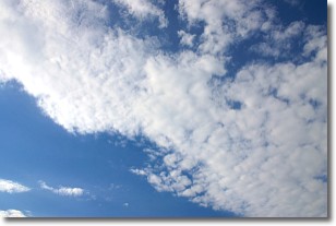
Weather Topic: What are Altocumulus Clouds?
Home - Education - Cloud Types - Altocumulus Clouds
 Next Topic: Altostratus Clouds
Similar to cirrocumulus clouds, altocumulus clouds are
characterized by cloud patches. They are distinguished by larger cloudlets
than cirrocumulus clouds but are still smaller than stratocumulus clouds.
Altocumulus clouds most commonly form in middle altitudes (between 2 and 5 km)
and may resemble, at times, the shape of a flying saucer.
These uncommon formations, called altocumulus lenticularis, are created by uplift
in the atmosphere and are most often seen in close proximity to mountains.
Next Topic: Altostratus Clouds
Weather Topic: What are Cirrocumulus Clouds?
Home - Education - Cloud Types - Cirrocumulus Clouds
 Next Topic: Cirrostratus Clouds
Cirrocumulus clouds form at high altitudes (usually around 5 km)
and have distinguishing characteristics displayed in a fine layer of
small cloud patches. These small cloud patches are sometimes referred to as
"cloudlets" in relation to the whole cloud formation.
Cirrocumulus clouds are formed from ice crystals and water droplets. Often, the
water droplets in the cloud freeze into ice crystals and the cloud becomes a
cirrostratus cloud. Because of this common occurrence, cirrocumulus cloud
formations generally pass rapidly.
Next Topic: Cirrostratus Clouds
Current conditions powered by WeatherAPI.com


