Weather Alert in Virginia
Flood Warning issued August 21 at 10:47PM EDT until August 22 at 8:45AM EDT by NWS Blacksburg VA
AREAS AFFECTED: Botetourt, VA; Franklin, VA; Roanoke, VA; City of Roanoke, VA; City of Salem, VA
DESCRIPTION: * WHAT...Urban area and small stream flooding caused by excessive rainfall is expected. * WHERE...A portion of west central Virginia, including the following counties and independent cities, Botetourt, City of Roanoke, City of Salem, Franklin and Roanoke. * WHEN...Until 845 AM EDT Friday. * IMPACTS...Flooding of rivers, creeks, streams, and other low-lying and flood-prone locations is occurring. Numerous roads remain closed due to flooding. Expect many areas of slow moving or standing water. Local media have reported water rescues earlier this evening. * ADDITIONAL DETAILS... - At 1046 PM EDT, Doppler radar and automated rain gauges indicated heavy rain due to thunderstorms. Flooding is already occurring in the warned area. Between 3 and 5 inches of rain have fallen. - This includes the following streams and drainages... Big Bear Rock Branch, Back Creek, Carvin Creek and Buffalo Creek. Flooding impacts will continue, but no additional rainfall is expected. - Some locations that will experience flooding include... Roanoke, Salem, Vinton, Boones Mill, Catawba, Cave Spring and Hollins. - http://www.weather.gov/safety/flood
INSTRUCTION: Turn around, don't drown when encountering flooded roads. Most flood deaths occur in vehicles. Be especially cautious at night when it is harder to recognize the dangers of flooding. When it is safe to do so, please send your reports of flooding, including mudslides or flooded roads, to the National Weather Service by calling toll free at 1...8 6 6...2 1 5...4 3 2 4. Reports and pictures can also be shared on the National Weather Service Blacksburg Facebook page and on X.
Want more detail? Get the Complete 7 Day and Night Detailed Forecast!
Current U.S. National Radar--Current
The Current National Weather Radar is shown below with a UTC Time (subtract 5 hours from UTC to get Eastern Time).

National Weather Forecast--Current
The Current National Weather Forecast and National Weather Map are shown below.

National Weather Forecast for Tomorrow
Tomorrow National Weather Forecast and Tomorrow National Weather Map are show below.

North America Water Vapor (Moisture)
This map shows recent moisture content over North America. Bright and colored areas show high moisture (ie, clouds); brown indicates very little moisture present; black indicates no moisture.

Weather Topic: What are Fractus Clouds?
Home - Education - Cloud Types - Fractus Clouds
 Next Topic: Freezing Rain
A fractus cloud (scud) is a fragmented, tattered cloud which has
likely been sheared off of another cloud. They are accessory clouds, meaning they
develop from parent clouds, and are named in a way which describes the original
cloud which contained them.
Fractus clouds which have originated from cumulus clouds are referred to as
cumulus fractus, while fractus clouds which have originated from stratus clouds
are referred to as stratus fractus. Under certain conditions a fractus cloud might
merge with another cloud, or develop into a cumulus cloud, but usually a
fractus cloud seen by itself will dissipate rapidly.
They are often observed on the leading and trailing edges of storm clouds,
and are a display of wind activity.
Next Topic: Freezing Rain
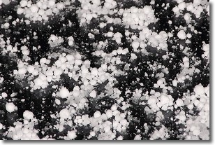
Weather Topic: What is Graupel?
Home - Education - Precipitation - Graupel
 Next Topic: Hail
Graupel is a form of precipitation that is created by atmospheric conditions
which cause supercooled water droplets to contact snow crystals and freeze to
their surface.
Sometimes known as soft hail or snow pellets, graupel is delicate and easily
destroyed by touch. Whereas hail usually falls during severe weather, graupel
doesn't require such conditions to form, and can form in mild precipitation
similar to situations which produce snowfall.
Next Topic: Hail
Current conditions powered by WeatherAPI.com


