Weather Alert in Nebraska
Flood Advisory issued September 1 at 11:56AM CDT until September 1 at 3:00PM CDT by NWS Omaha/Valley NE
AREAS AFFECTED: Jefferson, NE; Saline, NE
DESCRIPTION: * WHAT...Small stream flooding caused by excessive rainfall is expected. * WHERE...A portion of southeast Nebraska, including the following counties, Jefferson and Saline. * WHEN...Until 300 PM CDT. * IMPACTS...Minor flooding in low-lying and poor drainage areas. Rises in small streams and normally dry arroyos. Water over roadways. * ADDITIONAL DETAILS... - At 1153 AM CDT, Doppler radar indicated heavy rain due to thunderstorms this morning, bringing small stream flooding. Between 2 and 4 inches of rain have fallen. - Some locations that will experience flooding include... Fairbury, Wilber, Plymouth, Western, Daykin, Endicott, Jansen, Tobias, Swanton, Harbine, Cub Creek Recreational Area, Swan Creek Wildlife Management Area, The Highway 41 and 15 South Junction, Crystal Springs Campground, Willard Meyer Recreation Area, Rock Creek Station State Historical Park, Camp Jefferson, Gladstone and Swan Creek Reservoir Number 2.
INSTRUCTION: Turn around, don't drown when encountering flooded roads. Most flood deaths occur in vehicles. Be aware of your surroundings and do not drive on flooded roads.
Want more detail? Get the Complete 7 Day and Night Detailed Forecast!
Current U.S. National Radar--Current
The Current National Weather Radar is shown below with a UTC Time (subtract 5 hours from UTC to get Eastern Time).

National Weather Forecast--Current
The Current National Weather Forecast and National Weather Map are shown below.

National Weather Forecast for Tomorrow
Tomorrow National Weather Forecast and Tomorrow National Weather Map are show below.

North America Water Vapor (Moisture)
This map shows recent moisture content over North America. Bright and colored areas show high moisture (ie, clouds); brown indicates very little moisture present; black indicates no moisture.

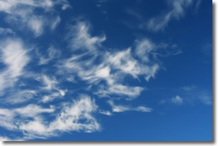
Weather Topic: What are Cirrostratus Clouds?
Home - Education - Cloud Types - Cirrostratus Clouds
 Next Topic: Cirrus Clouds
Cirrostratus clouds are high, thin clouds that form above
20,000 feet and are made mostly of ice crystals. They sometimes look like giant
feathers, horse tails, or curls of hair in the sky.
These clouds are pushed by the jet stream and can move at high speeds reaching
100 mph.
What do they indicate?
They indicate that a precipitation is likely within 24 hours.
Next Topic: Cirrus Clouds
Weather Topic: What is Condensation?
Home - Education - Precipitation - Condensation
 Next Topic: Contrails
Condensation is the process which creates clouds, and therefore
it is a crucial process in the water cycle.
Condensation is the change of matter from a state of gas into a state of liquid,
and it happens because water molecules release heat into the atmosphere and
become organized into a more closely packed structure, what we might see as
water droplets.
Water is always present in the air around us as a vapor, but it's too small for
us to see. When water undergoes the process of condensation it becomes organized
into visible water droplets. You've probably seen condensation happen before on the
surface of a cold drink!
Next Topic: Contrails
Current conditions powered by WeatherAPI.com


