Weather Alert in North Carolina
Coastal Flood Advisory issued August 22 at 10:56AM EDT until August 23 at 12:00AM EDT by NWS Newport/Morehead City NC
AREAS AFFECTED: Northern Outer Banks
DESCRIPTION: * WHAT...For the Coastal Flood Advisory, up to one to two feet of inundation above ground level near the beachfront. For the Beach Hazards Statement, dangerous rip currents. For the High Surf Advisory, large breaking waves of 6 to 10 feet in the surf zone. * WHERE...Northern Outer Banks north of Oregon Inlet. * WHEN...For the Coastal Flood Advisory, until midnight EDT tonight. For the Beach Hazards Statement, through this evening. For the High Surf Advisory, until midnight EDT tonight. * IMPACTS...Up to 1 to 2 feet of inundation above ground level is possible in low-lying areas near the beach front resulting in a low threat of property damage. Some low lying property including parking lots, parks, lawns, and homes adjacent to the waterfront may experience shallow flooding. Dangerous swimming and surfing conditions and localized beach erosion. Rip currents can sweep even the best swimmers away from shore into deeper water.
INSTRUCTION: Do not drive around barricades or through water of unknown depth. Take the necessary actions to protect flood-prone property. Life-threatening rip currents. If caught in a rip current, remain calm. Swim in a direction following the shoreline. If tired, float or tread water until out of the rip current. If unable to escape, face the shore and call or wave for help. Shore break occurs when waves break directly on the beach. It is extremely important to protect your head and neck whenever you are in breaking waves by keeping your hands in front of you at all times.
Want more detail? Get the Complete 7 Day and Night Detailed Forecast!
Current U.S. National Radar--Current
The Current National Weather Radar is shown below with a UTC Time (subtract 5 hours from UTC to get Eastern Time).

National Weather Forecast--Current
The Current National Weather Forecast and National Weather Map are shown below.

National Weather Forecast for Tomorrow
Tomorrow National Weather Forecast and Tomorrow National Weather Map are show below.

North America Water Vapor (Moisture)
This map shows recent moisture content over North America. Bright and colored areas show high moisture (ie, clouds); brown indicates very little moisture present; black indicates no moisture.

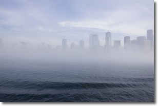
Weather Topic: What is Fog?
Home - Education - Cloud Types - Fog
 Next Topic: Fractus Clouds
Fog is technically a type of stratus cloud, which lies along the
ground and obscures visibility.
It is usually created when humidity in the air condenses into tiny water droplets.
Because of this, some places are more prone to foggy weather, such as regions
close to a body of water.
Fog is similar to mist; both are the appearance of water droplets suspended in
the air, but fog is the term applied to the condition when visibility is less than 1 km.
Next Topic: Fractus Clouds
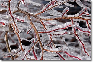
Weather Topic: What is Freezing Rain?
Home - Education - Precipitation - Freezing Rain
 Next Topic: Graupel
Freezing rain is a condition where precipitation which has fallen in the form of
water droplets reaches temperatures which are below freezing and freezes upon
coming into contact
with surface objects. The result of this precipitation is a glaze of ice which
can be damaging to plants and man-made structures. A severe onset of freezing
rain which results in a very thick glaze of ice is known as an ice storm.
Next Topic: Graupel
Current conditions powered by WeatherAPI.com


