Weather Alert in Arizona
Air Quality Alert issued August 22 at 10:02AM MST by NWS Phoenix AZ
AREAS AFFECTED: Pinal, AZ
DESCRIPTION: AQAPSR The Arizona Department of Environmental Quality (ADEQ) has issued a PM-10 High Pollution Advisory for Pinal County today. An episode of strong and gusty winds is forecast to generate widespread blowing dust that may result in local PM-10 concentrations that pose a health risk. Adverse health effects increase as air quality deteriorates. Coarse particulate matter - also known as PM-10 - is an air contaminant that can aggravate heart and lung disease conditions, especially in older adults, children, and those with asthma. A decrease in physical activity is recommended. Consolidate your travel, stabilize loose soils, slow down or avoid travel on dirt roads, reduce or eliminate fireplace use, and avoid using gas-powered lawn equipment. For details on this High Pollution Advisory, visit the ADEQ internet site at www.azdeq.gov/forecast/WestPinal or call 602-771-2300.
INSTRUCTION: N/A
Want more detail? Get the Complete 7 Day and Night Detailed Forecast!
Current U.S. National Radar--Current
The Current National Weather Radar is shown below with a UTC Time (subtract 5 hours from UTC to get Eastern Time).

National Weather Forecast--Current
The Current National Weather Forecast and National Weather Map are shown below.

National Weather Forecast for Tomorrow
Tomorrow National Weather Forecast and Tomorrow National Weather Map are show below.

North America Water Vapor (Moisture)
This map shows recent moisture content over North America. Bright and colored areas show high moisture (ie, clouds); brown indicates very little moisture present; black indicates no moisture.

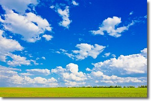
Weather Topic: What are Cumulus Clouds?
Home - Education - Cloud Types - Cumulus Clouds
 Next Topic: Drizzle
Cumulus clouds are fluffy and textured with rounded tops, and
may have flat bottoms. The border of a cumulus cloud
is clearly defined, and can have the appearance of cotton or cauliflower.
Cumulus clouds form at low altitudes (rarely above 2 km) but can grow very tall,
becoming cumulus congestus and possibly the even taller cumulonimbus clouds.
When cumulus clouds become taller, they have a greater chance of producing precipitation.
Next Topic: Drizzle
Weather Topic: What is Evaporation?
Home - Education - Precipitation - Evaporation
 Next Topic: Fog
Evaporation is the process which returns water from the earth
back to the atmosphere, and is another crucial process in the water cycle.
Evaporation is the transformation of liquid into gas, and it happens because
molecules are excited by the application of energy and turn into vapor.
In order for water to evaporate it has to be on the surface of a body of water.
Next Topic: Fog
Current conditions powered by WeatherAPI.com


