Weather Alert in Michigan
Red Flag Warning issued April 28 at 9:15AM EDT until April 28 at 6:00PM EDT by NWS Grand Rapids MI
AREAS AFFECTED: Mason; Lake; Osceola; Clare; Oceana; Newaygo; Mecosta; Muskegon
DESCRIPTION: The National Weather Service in Grand Rapids has issued a Red Flag Warning, which is in effect until 6 PM EDT this evening. * Winds...South 10 to 20 mph with gusts up to 30 mph. * Relative Humidity...As low as 28 percent. * Temperatures...In the mid 70s. * Impacts...Burn restrictions are likely in effect. For more information on burn restrictions...visit the Michigan DNR website at www.michigan.gov/burnpermit or call 866-922-2876.
INSTRUCTION: A Red Flag Warning means that critical fire weather conditions are either occurring now or will shortly. The combination of strong winds...low relative humidity...and warm temperatures can contribute to extreme fire behavior. Be careful with any activities that could potentially lead to a wildfire. Camping...outdoor grills...smoking materials...chain saws...and all terrain vehicles all have the potential to throw a spark and ignite a dangerous and destructive fire.
Want more detail? Get the Complete 7 Day and Night Detailed Forecast!
Current U.S. National Radar--Current
The Current National Weather Radar is shown below with a UTC Time (subtract 5 hours from UTC to get Eastern Time).

National Weather Forecast--Current
The Current National Weather Forecast and National Weather Map are shown below.

National Weather Forecast for Tomorrow
Tomorrow National Weather Forecast and Tomorrow National Weather Map are show below.

North America Water Vapor (Moisture)
This map shows recent moisture content over North America. Bright and colored areas show high moisture (ie, clouds); brown indicates very little moisture present; black indicates no moisture.

Weather Topic: What is Freezing Rain?
Home - Education - Precipitation - Freezing Rain
 Next Topic: Graupel
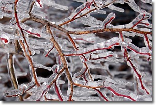
Freezing rain is a condition where precipitation which has fallen in the form of
water droplets reaches temperatures which are below freezing and freezes upon
coming into contact
with surface objects. The result of this precipitation is a glaze of ice which
can be damaging to plants and man-made structures. A severe onset of freezing
rain which results in a very thick glaze of ice is known as an ice storm.
Next Topic: Graupel
Weather Topic: What is Hail?
Home - Education - Precipitation - Hail
 Next Topic: Hole Punch Clouds
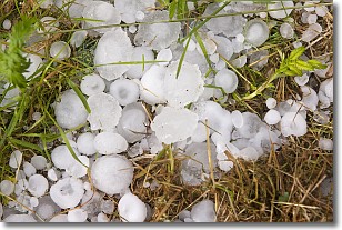
Hail is a form of precipitation which is recognized by large solid balls or
clumps of ice. Hail is created by thunderstorm clouds with strong updrafts of wind.
As the hailstones remain in the updraft, ice is deposited onto them until their
weight becomes heavy enough for them to fall to the earth's surface.
Hail storms can cause significant damage to crops, aircrafts, and man-made structures,
despite the fact that the duration is usually less than ten minutes.
Next Topic: Hole Punch Clouds
Current conditions powered by WeatherAPI.com


