Weather Alert in Maryland
Coastal Flood Advisory issued August 22 at 10:45AM EDT until August 25 at 6:00AM EDT by NWS Baltimore MD/Washington DC
AREAS AFFECTED: Southern Baltimore; Calvert; Southeast Harford
DESCRIPTION: * WHAT...Two to two and half feet of inundation above ground level in low lying areas due to tidal flooding. * WHERE...Southern Baltimore, Calvert and Southeast Harford Counties. * WHEN...Until 6 AM EDT Monday, especially around the time of high tide. * IMPACTS...At 4.25 feet, the concrete promenade at Fells Point begins to flood. Water also begins to cover the boardwalk at the Maritime Park water taxi stop. Thames Street is flooded, and much of the promenade in the Inner Harbor is flooded. At 3.0 feet, water begins encroaching upon yards in the Bowleys Quarters area. At 4.5 feet, portions of the Havre de Grace Yacht Basin are flooded, along with Hutchins Park. At 3.0 feet, water is expected to reach backyards near 9th Street in North Beach, and could approach 9th Street. At 3.5 feet, yards are flooded near Charles Street and Williams Street in Solomons. Nearby parking lots and the streets themselves are covered by more than a half foot of water. * ADDITIONAL DETAILS...Tides two to two and a half feet above normal. The next high tide at Chesapeake Beach is at 4:03 PM and 4:46 AM. The next high tide at Fort McHenry Baltimore is at 6:50 PM and 7:33 AM. The next high tide at Solomons Island is at 2:15 PM and 2:56 AM. The next high tide at Havre de Grace is at 10:20 PM and 10:26 AM.
INSTRUCTION: If travel is required, allow extra time as some roads may be closed. Do not drive around barricades or through water of unknown depth. Take the necessary actions to protect flood-prone property.
Want more detail? Get the Complete 7 Day and Night Detailed Forecast!
Current U.S. National Radar--Current
The Current National Weather Radar is shown below with a UTC Time (subtract 5 hours from UTC to get Eastern Time).

National Weather Forecast--Current
The Current National Weather Forecast and National Weather Map are shown below.

National Weather Forecast for Tomorrow
Tomorrow National Weather Forecast and Tomorrow National Weather Map are show below.

North America Water Vapor (Moisture)
This map shows recent moisture content over North America. Bright and colored areas show high moisture (ie, clouds); brown indicates very little moisture present; black indicates no moisture.

Weather Topic: What is Freezing Rain?
Home - Education - Precipitation - Freezing Rain
 Next Topic: Graupel
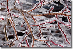
Freezing rain is a condition where precipitation which has fallen in the form of
water droplets reaches temperatures which are below freezing and freezes upon
coming into contact
with surface objects. The result of this precipitation is a glaze of ice which
can be damaging to plants and man-made structures. A severe onset of freezing
rain which results in a very thick glaze of ice is known as an ice storm.
Next Topic: Graupel
Weather Topic: What is Hail?
Home - Education - Precipitation - Hail
 Next Topic: Hole Punch Clouds
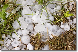
Hail is a form of precipitation which is recognized by large solid balls or
clumps of ice. Hail is created by thunderstorm clouds with strong updrafts of wind.
As the hailstones remain in the updraft, ice is deposited onto them until their
weight becomes heavy enough for them to fall to the earth's surface.
Hail storms can cause significant damage to crops, aircrafts, and man-made structures,
despite the fact that the duration is usually less than ten minutes.
Next Topic: Hole Punch Clouds
Current conditions powered by WeatherAPI.com


