Weather Alert in New Mexico
Red Flag Warning issued March 14 at 11:45AM MDT until March 15 at 8:00PM MDT by NWS Albuquerque NM
AREAS AFFECTED: Northwest Plateau; West Central Mountains; Middle Rio Grande Valley; West Central Basin and Range; North Central Mountains; Upper Rio Grande Valley and Lower Chama River Valley; Sangre de Cristo Mountains; Sandia and Manzano Mountains; East Central Plains
DESCRIPTION: ...RED FLAG WARNING TODAY FROM NOON UNTIL MIDNIGHT FOR THE NORTHEAST HIGHLANDS, NORTHEAST PLAINS, AND CENTRAL HIGHLANDS DUE TO STRONG WINDS AND LOW HUMIDITY... ...RED FLAG WARNING FROM 9 AM TO 8 PM SUNDAY FOR ALL OF NORTHERN AND CENTRAL NM DUE TO STRONG TO SEVERE WINDS AND LOW HUMIDITY... .Critical fire weather conditions will impact much of central and northern NM through Sunday. For today, westerly winds will linger longer across the central to northeast highlands and into the northeastern plains of New Mexico through late this evening. On Sunday, widespread critical fire weather will develop. Winds will turn very strong to potentially damaging as both a Pacific and backdoor cold front pass through the area. With gusts between 40 and 65 mph and single digit humidity values in many areas, critical to extreme fire weather conditions are likely despite cooling temperatures. The National Weather Service in Albuquerque has issued a Red Flag Warning...which is in effect from 9 AM to 8 PM MDT Sunday. The Fire Weather Watch is no longer in effect. * AREA AND TIMING...Northwest Plateau (Zone 101), West Central Mountains (Zone 105), Middle Rio Grande Valley (Zone 106), West Central Basin and Range (Zone 109), North Central Mountains (Zone 120), Upper Rio Grande Valley and Lower Chama River Valley (Zone 121), Sangre de Cristo Mountains (Zone 122), Sandia and Manzano Mountains (Zone 124), and East Central Plains (Zone 126) on Sunday from 9 AM through 8 PM. * 20 FOOT WINDS...North northwest winds 25 to 40 mph with gusts between 45 and 65 mph Sunday. * RELATIVE HUMIDITY...Minimum values between 6 and 15 percent with locally higher values across the peaks of the Tusas Mountains and Sangre de Cristo Mountains. * IMPACTS...Any fires that develop will likely spread rapidly. Outdoor burning is not recommended.
INSTRUCTION: Please advise the appropriate officials or fire crews in the field of this Red Flag Warning.
Want more detail? Get the Complete 7 Day and Night Detailed Forecast!
Current U.S. National Radar--Current
The Current National Weather Radar is shown below with a UTC Time (subtract 5 hours from UTC to get Eastern Time).

National Weather Forecast--Current
The Current National Weather Forecast and National Weather Map are shown below.

National Weather Forecast for Tomorrow
Tomorrow National Weather Forecast and Tomorrow National Weather Map are show below.

North America Water Vapor (Moisture)
This map shows recent moisture content over North America. Bright and colored areas show high moisture (ie, clouds); brown indicates very little moisture present; black indicates no moisture.

Weather Topic: What is Hail?
Home - Education - Precipitation - Hail
 Next Topic: Hole Punch Clouds
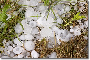
Hail is a form of precipitation which is recognized by large solid balls or
clumps of ice. Hail is created by thunderstorm clouds with strong updrafts of wind.
As the hailstones remain in the updraft, ice is deposited onto them until their
weight becomes heavy enough for them to fall to the earth's surface.
Hail storms can cause significant damage to crops, aircrafts, and man-made structures,
despite the fact that the duration is usually less than ten minutes.
Next Topic: Hole Punch Clouds
Weather Topic: What are Mammatus Clouds?
Home - Education - Cloud Types - Mammatus Clouds
 Next Topic: Nimbostratus Clouds
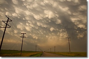
A mammatus cloud is a cloud with a unique feature which resembles
a web of pouches hanging along the base of the cloud.
In the United States, mammatus clouds tend to form in the warmer months, commonly
in the Midwest and eastern regions.
While they usually form at the bottom of a cumulonimbis cloud, they can also form
under altostratus, altocumulus, stratocumulus, and cirrus clouds. Mammatus clouds
warn that severe weather is close.
Next Topic: Nimbostratus Clouds
Current conditions powered by WeatherAPI.com


