Weather Alert in Washington
Red Flag Warning issued July 30 at 1:35PM PDT until July 31 at 8:00PM PDT by NWS Pendleton OR
AREAS AFFECTED: East Washington South Central Cascade Mountains
DESCRIPTION: ...RED FLAG WARNING IN EFFECT FROM 1 PM WEDNESDAY TO 11 AM THURSDAY FOR ABUNDANT LIGHTNING FOR FIRE WEATHER ZONES OR700, OR704, AND OR705... ...RED FLAG WARNING IN EFFECT FROM 1 PM TO 9 PM WEDNESDAY FOR ABUNDANT LIGHTNING FOR FIRE WEATHER ZONE WA695... .Multiple rounds of showers and thunderstorms are forecast through Friday. While some of these storms may produce wetting rains, their high-based nature will increase the probability of scattered (Wednesday) dry thunderstorms. Showers and thunderstorms will be capable of producing gusty and erratic outflow winds up to 60 mph. The National Weather Service in Pendleton has issued a Red Flag Warning for abundant lightning, which is in effect from 11 AM to 8 PM PDT Thursday. * AFFECTED AREA...Fire Weather Zone 695 East Washington South Central Cascade Mountains. * TIMING...For the first Red Flag Warning, until 9 PM PDT this evening. For the second Red Flag Warning, from 11 AM to 8 PM PDT Thursday. * IMPACTS...Any fire that develops will catch and spread quickly. Outdoor burning is not recommended. * THUNDERSTORMS...Abundant lightning and isolated dry thunderstorms. * OUTFLOW WINDS...Gusty, erratic winds with gusts up to 50 mph.
INSTRUCTION: A Red Flag Warning means that critical fire weather conditions are either occurring now, or will shortly. A combination of strong winds, low relative humidity, and warm temperatures can contribute to extreme fire behavior.
Want more detail? Get the Complete 7 Day and Night Detailed Forecast!
Current U.S. National Radar--Current
The Current National Weather Radar is shown below with a UTC Time (subtract 5 hours from UTC to get Eastern Time).

National Weather Forecast--Current
The Current National Weather Forecast and National Weather Map are shown below.

National Weather Forecast for Tomorrow
Tomorrow National Weather Forecast and Tomorrow National Weather Map are show below.

North America Water Vapor (Moisture)
This map shows recent moisture content over North America. Bright and colored areas show high moisture (ie, clouds); brown indicates very little moisture present; black indicates no moisture.

Weather Topic: What is Sleet?
Home - Education - Precipitation - Sleet
 Next Topic: Snow
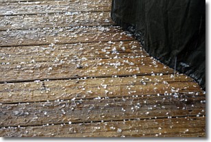
Sleet is a form of precipitation in which small ice pellets are the primary
components. These ice pellets are smaller and more translucent than hailstones,
and harder than graupel. Sleet is caused by specific atmospheric conditions and
therefore typically doesn't last for extended periods of time.
The condition which leads to sleet formation requires a warmer body of air to be
wedged in between two sub-freezing bodies of air. When snow falls through a warmer
layer of air it melts, and as it falls through the next sub-freezing body of air
it freezes again, forming ice pellets known as sleet. In some cases, water
droplets don't have time to freeze before reaching the surface and the result is
freezing rain.
Next Topic: Snow
Weather Topic: What are Stratocumulus Clouds?
Home - Education - Cloud Types - Stratocumulus Clouds
 Next Topic: Stratus Clouds
Stratocumulus clouds are similar to altocumulus clouds in their
fluffy appearance, but have a slightly darker shade due to their additional mass.
A good way to distinguish the two cloud types is to hold your hand out and measure
the size of an individual cloud; if it is the size of your thumb it is generally
an altocumulus cloud, if it is the size of your hand it is generally a
stratocumulus cloud.
It is uncommon for stratocumulus clouds to produce precipitation, but if they do
it is usually a light rain or snow.
Next Topic: Stratus Clouds
Current conditions powered by WeatherAPI.com


