Weather Alert in Minnesota
Blizzard Warning issued March 15 at 12:05PM CDT until March 16 at 4:00AM CDT by NWS Twin Cities/Chanhassen MN
AREAS AFFECTED: Chisago; Hennepin; Anoka; Ramsey; Washington; Carver; Polk
DESCRIPTION: ...INCREASING WIND SPEEDS WILL LEAD TO BLOWING SNOW AND BLIZZARD CONDITIONS THIS AFTERNOON AND TONIGHT... ...LIGHT TO MODERATE SNOW WILL CONTINUE THROUGH THE AFTERNOON... .Widespread snowfall amounts over 8 inches through this morning fell along and south of a line from Rice Lake in Wisconsin, to the Twin Cities, and Redwood Falls. An additional 3 to 6 inches of snow is expected through the afternoon in these area. Travel conditions will continue to deteriorate this afternoon as northwest wind gusts increase to between 40 and 50 mph, with gusts to 55 mph possible along the I-90 corridor. The combination of falling snow, blowing snow, and gusty winds will reduce visibility and create blizzard conditions into tonight. * WHAT...Blizzard conditions. Additional snow accumulations between 1 and 3 inches. Winds gusting as high as 40 mph. * WHERE...In Minnesota, Anoka, Carver, Chisago, Hennepin, Ramsey, and Washington Counties. In Wisconsin, Polk County. * WHEN...Until 4 AM CDT Monday. * IMPACTS...Plan on slippery road conditions. Widespread blowing snow could significantly reduce visibility.
INSTRUCTION: Travel should be restricted to emergencies only. If you must travel, have a winter survival kit with you. If you get stranded, stay with your vehicle. In Minnesota, call 5 1 1 or visit 511mn.org for road conditions. In Wisconsin, call 5 1 1 or visit 511wi.gov for road conditions.
Want more detail? Get the Complete 7 Day and Night Detailed Forecast!
Current U.S. National Radar--Current
The Current National Weather Radar is shown below with a UTC Time (subtract 5 hours from UTC to get Eastern Time).

National Weather Forecast--Current
The Current National Weather Forecast and National Weather Map are shown below.

National Weather Forecast for Tomorrow
Tomorrow National Weather Forecast and Tomorrow National Weather Map are show below.

North America Water Vapor (Moisture)
This map shows recent moisture content over North America. Bright and colored areas show high moisture (ie, clouds); brown indicates very little moisture present; black indicates no moisture.

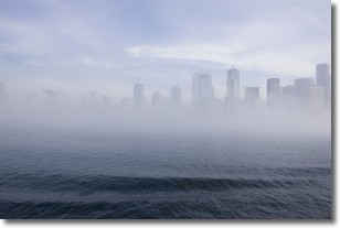
Weather Topic: What is Fog?
Home - Education - Cloud Types - Fog
 Next Topic: Fractus Clouds
Fog is technically a type of stratus cloud, which lies along the
ground and obscures visibility.
It is usually created when humidity in the air condenses into tiny water droplets.
Because of this, some places are more prone to foggy weather, such as regions
close to a body of water.
Fog is similar to mist; both are the appearance of water droplets suspended in
the air, but fog is the term applied to the condition when visibility is less than 1 km.
Next Topic: Fractus Clouds
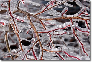
Weather Topic: What is Freezing Rain?
Home - Education - Precipitation - Freezing Rain
 Next Topic: Graupel
Freezing rain is a condition where precipitation which has fallen in the form of
water droplets reaches temperatures which are below freezing and freezes upon
coming into contact
with surface objects. The result of this precipitation is a glaze of ice which
can be damaging to plants and man-made structures. A severe onset of freezing
rain which results in a very thick glaze of ice is known as an ice storm.
Next Topic: Graupel
Current conditions powered by WeatherAPI.com


