Weather Alert in Minnesota
Blizzard Warning issued March 15 at 12:05PM CDT until March 16 at 7:00AM CDT by NWS Twin Cities/Chanhassen MN
AREAS AFFECTED: Martin; Faribault; Freeborn
DESCRIPTION: ...INCREASING WIND SPEEDS WILL LEAD TO BLOWING SNOW AND BLIZZARD CONDITIONS THIS AFTERNOON AND TONIGHT... ...LIGHT TO MODERATE SNOW WILL CONTINUE THROUGH THE AFTERNOON... .Widespread snowfall amounts over 8 inches through this morning fell along and south of a line from Rice Lake in Wisconsin, to the Twin Cities, and Redwood Falls. An additional 3 to 6 inches of snow is expected through the afternoon in these area. Travel conditions will continue to deteriorate this afternoon as northwest wind gusts increase to between 40 and 50 mph, with gusts to 55 mph possible along the I-90 corridor. The combination of falling snow, blowing snow, and gusty winds will reduce visibility and create blizzard conditions into tonight. * WHAT...Blizzard conditions. Additional snow accumulations between 3 and 5 inches. Winds gusting as high as 55 mph. * WHERE...Faribault, Freeborn, and Martin Counties. * WHEN...Until 7 AM CDT Monday. * IMPACTS...Whiteout conditions are expected and will make travel treacherous and potentially life-threatening. Plan on slippery road conditions. Widespread blowing snow could significantly reduce visibility. The hazardous conditions will impact the Monday morning commute. Strong winds could cause extensive damage to trees and power lines.
INSTRUCTION: Travel should be restricted to emergencies only. If you must travel, have a winter survival kit with you. If you get stranded, stay with your vehicle. Call 5 1 1 or visit 511mn.org for road conditions. Prepare now for potential road closures. Delay travel and shelter in place once conditions worsen. Remember, if interstate highways are closed, state highways and county roads are also impassable.
Want more detail? Get the Complete 7 Day and Night Detailed Forecast!
Current U.S. National Radar--Current
The Current National Weather Radar is shown below with a UTC Time (subtract 5 hours from UTC to get Eastern Time).

National Weather Forecast--Current
The Current National Weather Forecast and National Weather Map are shown below.

National Weather Forecast for Tomorrow
Tomorrow National Weather Forecast and Tomorrow National Weather Map are show below.

North America Water Vapor (Moisture)
This map shows recent moisture content over North America. Bright and colored areas show high moisture (ie, clouds); brown indicates very little moisture present; black indicates no moisture.

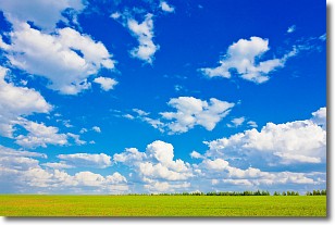
Weather Topic: What are Cumulus Clouds?
Home - Education - Cloud Types - Cumulus Clouds
 Next Topic: Drizzle
Cumulus clouds are fluffy and textured with rounded tops, and
may have flat bottoms. The border of a cumulus cloud
is clearly defined, and can have the appearance of cotton or cauliflower.
Cumulus clouds form at low altitudes (rarely above 2 km) but can grow very tall,
becoming cumulus congestus and possibly the even taller cumulonimbus clouds.
When cumulus clouds become taller, they have a greater chance of producing precipitation.
Next Topic: Drizzle
Weather Topic: What is Evaporation?
Home - Education - Precipitation - Evaporation
 Next Topic: Fog
Evaporation is the process which returns water from the earth
back to the atmosphere, and is another crucial process in the water cycle.
Evaporation is the transformation of liquid into gas, and it happens because
molecules are excited by the application of energy and turn into vapor.
In order for water to evaporate it has to be on the surface of a body of water.
Next Topic: Fog
Current conditions powered by WeatherAPI.com


