Weather Alert in California
Special Weather Statement issued August 23 at 10:27AM PDT by NWS Los Angeles/Oxnard CA
AREAS AFFECTED: Santa Clarita Valley; Central Ventura County Valleys; Southern Ventura County Mountains; Northern Ventura County Mountains; Interstate 5 Corridor; Western San Gabriel Mountains and Highway 14 Corridor; Western Antelope Valley Foothills; Antelope Valley
DESCRIPTION: At 1025 AM PDT, Doppler radar was tracking a strong thunderstorm near Lake Hughes, or 16 miles north of Santa Clarita, moving northwest at 25 mph. HAZARD...Erratic wind gusts of 35 to 50 mph. SOURCE...Radar indicated. IMPACT...Gusty winds could knock down tree limbs and blow around unsecured objects. Within the next hour, this storm will likely affect the following areas of northeastern Ventura and northwestern Los Angeles Counties...Pyramid Lake, Interstate 5 over the Grapevine, Gorman, Frazier Mountain, Highway 138 between Quail Lake and Lancaster, and Castaic Lake.
INSTRUCTION: If outdoors, consider seeking shelter inside a building. Frequent cloud to ground lightning is occurring with this storm. Lightning can strike 10 miles away from a thunderstorm. Seek a safe shelter inside a building or vehicle. This storm may intensify. Continue to monitor the situation through local media sources and the National Weather Service.
Want more detail? Get the Complete 7 Day and Night Detailed Forecast!
Current U.S. National Radar--Current
The Current National Weather Radar is shown below with a UTC Time (subtract 5 hours from UTC to get Eastern Time).

National Weather Forecast--Current
The Current National Weather Forecast and National Weather Map are shown below.

National Weather Forecast for Tomorrow
Tomorrow National Weather Forecast and Tomorrow National Weather Map are show below.

North America Water Vapor (Moisture)
This map shows recent moisture content over North America. Bright and colored areas show high moisture (ie, clouds); brown indicates very little moisture present; black indicates no moisture.

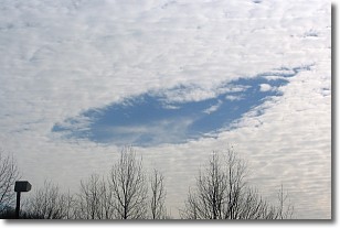
Weather Topic: What are Hole Punch Clouds?
Home - Education - Cloud Types - Hole Punch Clouds
 Next Topic: Mammatus Clouds
A hole punch cloud is an unusual occurrence when a disk-shaped
hole appears in a cirrostratus, cirrocumulus, or altocumulus cloud.
When part of the cloud forms ice crystals, water droplets in the surrounding area
of the cloud evaporate. The effect of this process produces a large elliptical
gap in the cloud. The hole punch cloud formation is rare, but it is not specific
to any geographic area.
Other names which have been used to describe this phenomena include fallstreak hole,
skypunch, and cloud hole.
Next Topic: Mammatus Clouds
Weather Topic: What are Nimbostratus Clouds?
Home - Education - Cloud Types - Nimbostratus Clouds
 Next Topic: Precipitation
A nimbostratus cloud is similar to a stratus cloud in its formless,
smooth appearance. However, a nimbostratus cloud is darker than a stratus cloud,
because it is thicker.
Unlike a stratus cloud, a nimbostratus cloud typically brings with it the threat
of moderate to heavy precipitation. In some cases, the precipitation may evaporate
before reaching the ground, a phenomenon known as virga.
Next Topic: Precipitation
Current conditions powered by WeatherAPI.com


