Weather Alert in Michigan
Blizzard Warning issued March 14 at 2:04PM EDT until March 17 at 2:00AM EDT by NWS Marquette MI
AREAS AFFECTED: Baraga; Marquette
DESCRIPTION: * WHAT...Blizzard conditions expected. Total snow accumulations between 2 and 3 feet, locally higher amounts up to 4 feet possible. Winds gusting as high as 60 mph, strongest near Lake Superior. * WHERE...Baraga and Marquette Counties. * WHEN...From 5 AM Sunday to 2 AM EDT Tuesday. * IMPACTS...Travel will be treacherous and potentially life-threatening. Widespread blowing snow and heavy snowfall rates will significantly reduce visibility. Strong winds could cause tree damage and result in power outages. * ADDITIONAL DETAILS...Heavy snowfall rates of 1 to 3 inches per hour are expected much of the day Sunday. Strongest winds late Sunday afternoon into Monday.
INSTRUCTION: Travel should be restricted to emergencies only. If you must travel, have a winter survival kit with you. If you get stranded, stay with your vehicle.
Want more detail? Get the Complete 7 Day and Night Detailed Forecast!
Current U.S. National Radar--Current
The Current National Weather Radar is shown below with a UTC Time (subtract 5 hours from UTC to get Eastern Time).

National Weather Forecast--Current
The Current National Weather Forecast and National Weather Map are shown below.

National Weather Forecast for Tomorrow
Tomorrow National Weather Forecast and Tomorrow National Weather Map are show below.

North America Water Vapor (Moisture)
This map shows recent moisture content over North America. Bright and colored areas show high moisture (ie, clouds); brown indicates very little moisture present; black indicates no moisture.

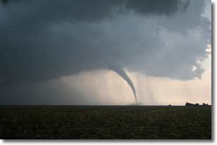
Weather Topic: What are Wall Clouds?
Home - Education - Cloud Types - Wall Clouds
 Next Topic: Altocumulus Clouds
A wall cloud forms underneath the base of a cumulonimbus cloud,
and can be a hotbed for deadly tornadoes.
Wall clouds are formed by air flowing into the cumulonimbus clouds, which can
result in the wall cloud descending from the base of the cumulonimbus cloud, or
rising fractus clouds which join to the base of the storm cloud as the wall cloud
takes shape.
Wall clouds can be very large, and in the Northern Hemisphere they generally
form at the southern edge of cumulonimbus clouds.
Next Topic: Altocumulus Clouds
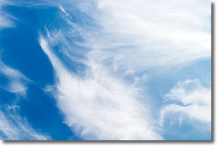
Weather Topic: What are Altostratus Clouds?
Home - Education - Cloud Types - Altostratus Clouds
 Next Topic: Cirrocumulus Clouds
Altostratus clouds form at mid to high-level altitudes
(between 2 and 7 km) and are created by a warm, stable air mass which causes
water vapor
to condense as it rise through the atmosphere. Usually altostratus clouds are
featureless sheets characterized by a uniform color.
In some cases, wind punching through the cloud formation may give it a waved
appearance, called altostratus undulatus. Altostratus clouds
are commonly seen with other cloud formations accompanying them.
Next Topic: Cirrocumulus Clouds
Current conditions powered by WeatherAPI.com


