Weather Alert in Wyoming
Air Quality Alert issued August 21 at 10:45PM MDT by NWS Riverton WY
AREAS AFFECTED: Southwest Bighorn Basin
DESCRIPTION: The following message is transmitted on behalf of the Wyoming Department of Environmental Quality, Air Quality Division, and the Wyoming Department of Health. * WHAT...Air Quality Alert for Wildfire Smoke. * WHERE...Hot Springs County, mainly near the Red Canyon Wildfire in eastern Hot Springs County. * WHEN...1 PM Thursday August 21 through 1 PM Friday August 22. * IMPACTS...Smoke from the Red Canyon Fire, will continue to spread across the area today into Friday morning. HEALTH INFORMATION...The Wyoming Department of Health recommends that the elderly, young children, and individuals with respiratory problems avoid excessive physical exertion and minimize outdoor activities during this time. Wildfire smoke is made up of a variety of pollutants, including particulate matter and ozone, which can cause respiratory health effects. Although these people are most susceptible to health impacts, the Department of Health also advises that everyone should avoid prolonged exposure to poor air quality conditions. CURRENT CONDITIONS...The Wyoming Department of Environmental Quality, Air Quality Division offers near real-time air quality data for Wyoming's monitoring stations and health effects information to help the public interpret current conditions. Current air quality conditions across the state of Wyoming can be found at http://www.wyvisnet.com/.
INSTRUCTION: N/A
Want more detail? Get the Complete 7 Day and Night Detailed Forecast!
Current U.S. National Radar--Current
The Current National Weather Radar is shown below with a UTC Time (subtract 5 hours from UTC to get Eastern Time).

National Weather Forecast--Current
The Current National Weather Forecast and National Weather Map are shown below.

National Weather Forecast for Tomorrow
Tomorrow National Weather Forecast and Tomorrow National Weather Map are show below.

North America Water Vapor (Moisture)
This map shows recent moisture content over North America. Bright and colored areas show high moisture (ie, clouds); brown indicates very little moisture present; black indicates no moisture.

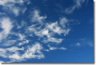
Weather Topic: What are Cirrostratus Clouds?
Home - Education - Cloud Types - Cirrostratus Clouds
 Next Topic: Cirrus Clouds
Cirrostratus clouds are high, thin clouds that form above
20,000 feet and are made mostly of ice crystals. They sometimes look like giant
feathers, horse tails, or curls of hair in the sky.
These clouds are pushed by the jet stream and can move at high speeds reaching
100 mph.
What do they indicate?
They indicate that a precipitation is likely within 24 hours.
Next Topic: Cirrus Clouds
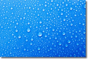
Weather Topic: What is Condensation?
Home - Education - Precipitation - Condensation
 Next Topic: Contrails
Condensation is the process which creates clouds, and therefore
it is a crucial process in the water cycle.
Condensation is the change of matter from a state of gas into a state of liquid,
and it happens because water molecules release heat into the atmosphere and
become organized into a more closely packed structure, what we might see as
water droplets.
Water is always present in the air around us as a vapor, but it's too small for
us to see. When water undergoes the process of condensation it becomes organized
into visible water droplets. You've probably seen condensation happen before on the
surface of a cold drink!
Next Topic: Contrails
Current conditions powered by WeatherAPI.com


