Weather Alert in South Carolina
Flash Flood Warning issued August 22 at 5:41PM EDT until August 22 at 9:00PM EDT by NWS Charleston SC
AREAS AFFECTED: Berkeley, SC; Charleston, SC; Dorchester, SC
DESCRIPTION: FFWCHS The National Weather Service in Charleston has extended the * Flash Flood Warning for... Berkeley County in southeastern South Carolina... Charleston County in southeastern South Carolina... Dorchester County in southeastern South Carolina... * Until 900 PM EDT. * At 541 PM EDT, Emergency management officials reported flash flooding is ongoing across the warned area. Roads remain closed and are flooded across portions of Dorchester County as well as Berkeley County. Water has entered homes around Knightsville and Summerville. As much as 2 to 6 inches of rain have fallen in this area today. Up to an additional inch could fall through 9 PM. The risk for additional flash flooding continues, especially near streams and creeks. Dorchester County Emergency Management is requesting that people stay off the roads and remain at home. HAZARD...Life threatening flash flooding. Thunderstorms producing flash flooding. SOURCE...Emergency management reported. IMPACT...Life threatening flash flooding of creeks and streams, urban areas, highways, streets and underpasses. * Some locations that will experience flash flooding include... North Charleston, Summerville, Goose Creek, Hanahan, Ladson, Givhans Ferry State Park, Ridgeville, Sangaree, College Park and Knightsville. This includes I-26 between mile markers 194 and 207.
INSTRUCTION: Keep children away from storm drains, culverts, creeks and streams. Water levels can rise rapidly and sweep children away. Be aware of your surroundings and do not drive on flooded roads.
Want more detail? Get the Complete 7 Day and Night Detailed Forecast!
Current U.S. National Radar--Current
The Current National Weather Radar is shown below with a UTC Time (subtract 5 hours from UTC to get Eastern Time).

National Weather Forecast--Current
The Current National Weather Forecast and National Weather Map are shown below.

National Weather Forecast for Tomorrow
Tomorrow National Weather Forecast and Tomorrow National Weather Map are show below.

North America Water Vapor (Moisture)
This map shows recent moisture content over North America. Bright and colored areas show high moisture (ie, clouds); brown indicates very little moisture present; black indicates no moisture.

Weather Topic: What is Sleet?
Home - Education - Precipitation - Sleet
 Next Topic: Snow
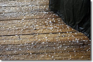
Sleet is a form of precipitation in which small ice pellets are the primary
components. These ice pellets are smaller and more translucent than hailstones,
and harder than graupel. Sleet is caused by specific atmospheric conditions and
therefore typically doesn't last for extended periods of time.
The condition which leads to sleet formation requires a warmer body of air to be
wedged in between two sub-freezing bodies of air. When snow falls through a warmer
layer of air it melts, and as it falls through the next sub-freezing body of air
it freezes again, forming ice pellets known as sleet. In some cases, water
droplets don't have time to freeze before reaching the surface and the result is
freezing rain.
Next Topic: Snow
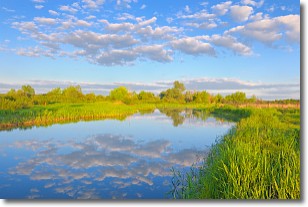
Weather Topic: What are Stratocumulus Clouds?
Home - Education - Cloud Types - Stratocumulus Clouds
 Next Topic: Stratus Clouds
Stratocumulus clouds are similar to altocumulus clouds in their
fluffy appearance, but have a slightly darker shade due to their additional mass.
A good way to distinguish the two cloud types is to hold your hand out and measure
the size of an individual cloud; if it is the size of your thumb it is generally
an altocumulus cloud, if it is the size of your hand it is generally a
stratocumulus cloud.
It is uncommon for stratocumulus clouds to produce precipitation, but if they do
it is usually a light rain or snow.
Next Topic: Stratus Clouds
Current conditions powered by WeatherAPI.com


