Weather Alert in South Carolina
Flash Flood Warning issued August 22 at 5:41PM EDT until August 22 at 9:00PM EDT by NWS Charleston SC
AREAS AFFECTED: Berkeley, SC; Charleston, SC; Dorchester, SC
DESCRIPTION: FFWCHS The National Weather Service in Charleston has extended the * Flash Flood Warning for... Berkeley County in southeastern South Carolina... Charleston County in southeastern South Carolina... Dorchester County in southeastern South Carolina... * Until 900 PM EDT. * At 541 PM EDT, Emergency management officials reported flash flooding is ongoing across the warned area. Roads remain closed and are flooded across portions of Dorchester County as well as Berkeley County. Water has entered homes around Knightsville and Summerville. As much as 2 to 6 inches of rain have fallen in this area today. Up to an additional inch could fall through 9 PM. The risk for additional flash flooding continues, especially near streams and creeks. Dorchester County Emergency Management is requesting that people stay off the roads and remain at home. HAZARD...Life threatening flash flooding. Thunderstorms producing flash flooding. SOURCE...Emergency management reported. IMPACT...Life threatening flash flooding of creeks and streams, urban areas, highways, streets and underpasses. * Some locations that will experience flash flooding include... North Charleston, Summerville, Goose Creek, Hanahan, Ladson, Givhans Ferry State Park, Ridgeville, Sangaree, College Park and Knightsville. This includes I-26 between mile markers 194 and 207.
INSTRUCTION: Keep children away from storm drains, culverts, creeks and streams. Water levels can rise rapidly and sweep children away. Be aware of your surroundings and do not drive on flooded roads.
Want more detail? Get the Complete 7 Day and Night Detailed Forecast!
Current U.S. National Radar--Current
The Current National Weather Radar is shown below with a UTC Time (subtract 5 hours from UTC to get Eastern Time).

National Weather Forecast--Current
The Current National Weather Forecast and National Weather Map are shown below.

National Weather Forecast for Tomorrow
Tomorrow National Weather Forecast and Tomorrow National Weather Map are show below.

North America Water Vapor (Moisture)
This map shows recent moisture content over North America. Bright and colored areas show high moisture (ie, clouds); brown indicates very little moisture present; black indicates no moisture.

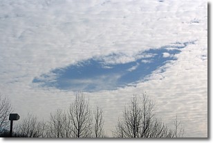
Weather Topic: What are Hole Punch Clouds?
Home - Education - Cloud Types - Hole Punch Clouds
 Next Topic: Mammatus Clouds
A hole punch cloud is an unusual occurrence when a disk-shaped
hole appears in a cirrostratus, cirrocumulus, or altocumulus cloud.
When part of the cloud forms ice crystals, water droplets in the surrounding area
of the cloud evaporate. The effect of this process produces a large elliptical
gap in the cloud. The hole punch cloud formation is rare, but it is not specific
to any geographic area.
Other names which have been used to describe this phenomena include fallstreak hole,
skypunch, and cloud hole.
Next Topic: Mammatus Clouds
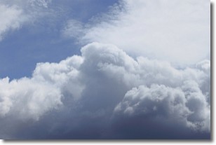
Weather Topic: What are Nimbostratus Clouds?
Home - Education - Cloud Types - Nimbostratus Clouds
 Next Topic: Precipitation
A nimbostratus cloud is similar to a stratus cloud in its formless,
smooth appearance. However, a nimbostratus cloud is darker than a stratus cloud,
because it is thicker.
Unlike a stratus cloud, a nimbostratus cloud typically brings with it the threat
of moderate to heavy precipitation. In some cases, the precipitation may evaporate
before reaching the ground, a phenomenon known as virga.
Next Topic: Precipitation
Current conditions powered by WeatherAPI.com


