Weather Alert in Arizona
Extreme Heat Watch issued March 14 at 12:21PM MST until March 22 at 8:00PM MST by NWS Tucson AZ
AREAS AFFECTED: Upper Santa Cruz River and Altar Valleys including Nogales; Upper San Pedro River Valley including Sierra Vista/Benson; Eastern Cochise County Below 5000 Feet including Douglas/Willcox; Upper Gila River and Aravaipa Valleys including Clifton/Safford
DESCRIPTION: * WHAT...Dangerously hot conditions with high temperatures 95 to 100 degrees. The hottest days are currently expected to be Friday March 20 and Saturday March 21. * WHERE...Eastern Cochise County below 5000 feet, Upper Gila River Valley, Upper San Pedro River Valley, and Upper Santa Cruz River Valley/Altar Valley. * WHEN...From Thursday morning through Sunday, March 22. * IMPACTS...Heat related illnesses increase significantly during extreme heat events. * ADDITIONAL DETAILS...Visitors, seasonal residents and other people not typically accustomed to or acclimated to extreme heat are especially urged to take precautions during the hottest hours of the day and limit outdoor activity.
INSTRUCTION: Do not leave young children and pets in unattended vehicles. Car interiors will reach lethal temperatures in a matter of minutes. Take extra precautions if you work or spend time outside. When possible, reschedule strenuous activities to early morning or evening. Know the signs and symptoms of heat exhaustion and heat stroke. Wear lightweight and loose fitting clothing when possible and drink plenty of water. To reduce risk during outdoor work, the Occupational Safety and Health Administration recommends scheduling frequent rest breaks in shaded or air conditioned environments. Anyone overcome by heat should be moved to a cool and shaded location. Heat stroke is an emergency! Call 9 1 1.
Want more detail? Get the Complete 7 Day and Night Detailed Forecast!
Current U.S. National Radar--Current
The Current National Weather Radar is shown below with a UTC Time (subtract 5 hours from UTC to get Eastern Time).

National Weather Forecast--Current
The Current National Weather Forecast and National Weather Map are shown below.

National Weather Forecast for Tomorrow
Tomorrow National Weather Forecast and Tomorrow National Weather Map are show below.

North America Water Vapor (Moisture)
This map shows recent moisture content over North America. Bright and colored areas show high moisture (ie, clouds); brown indicates very little moisture present; black indicates no moisture.

Weather Topic: What is Drizzle?
Home - Education - Precipitation - Drizzle
 Next Topic: Evaporation
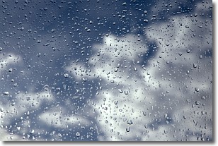
Drizzle is precipitation in the form of water droplets which are
smaller than raindrops.
Drizzle is characterized by fine, gently falling droplets and typically does not
impact human habitation in a negative way. The exception to this is freezing drizzle,
a condition where drizzle freezes immediately upon reaching earth's surface.
Freezing drizzle is still less dangerous than freezing rain, but can
potentially result in hazardous road conditions.
Next Topic: Evaporation
Weather Topic: What is Fog?
Home - Education - Cloud Types - Fog
 Next Topic: Fractus Clouds
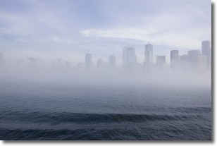
Fog is technically a type of stratus cloud, which lies along the
ground and obscures visibility.
It is usually created when humidity in the air condenses into tiny water droplets.
Because of this, some places are more prone to foggy weather, such as regions
close to a body of water.
Fog is similar to mist; both are the appearance of water droplets suspended in
the air, but fog is the term applied to the condition when visibility is less than 1 km.
Next Topic: Fractus Clouds
Current conditions powered by WeatherAPI.com


