Weather Alert in California
Heat Advisory issued March 14 at 12:56PM PDT until March 20 at 8:00PM PDT by NWS San Francisco CA
AREAS AFFECTED: San Francisco; Marin Coastal Range; Sonoma Coastal Range; North Bay Interior Mountains; Coastal North Bay Including Point Reyes National Seashore; North Bay Interior Valleys; San Francisco Bay Shoreline; San Francisco Peninsula Coast; East Bay Interior Valleys; Santa Cruz Mountains; Santa Clara Valley Including San Jose; Eastern Santa Clara Hills; East Bay Hills; Southern Salinas Valley/Arroyo Seco and Lake San Antonio; Santa Lucia Mountains and Los Padres National Forest; Mountains Of San Benito County And Interior Monterey County Including Pinnacles National Park; Northern Salinas Valley/Hollister Valley and Carmel Valley; Northern Monterey Bay; Southern Monterey Bay and Big Sur Coast
DESCRIPTION: * WHAT...High temperatures in the low to mid 90s across the interior and 80s along the coastline * WHERE...The Bay Area and Central Coast * WHEN...From 10 AM Monday to 8 PM PDT Friday. * IMPACTS...This level of heat affects most individuals sensitive to heat, especially those without effective cooling and/or adequate hydration. Impacts possible in some health systems and in heat-sensitive industries. Hot conditions can cause heat illnesses. * ADDITIONAL DETAILS...Much above normal temperatures in the upper 80s to mid 90s are expected next week across the Bay Area and Central Coast. Portions of the interior Central Coast may reach the upper 90s starting mid to late week. Overnight lows in the upper 50s to low 60s will offer some relief to the lower elevations but will offer minimal relief within the higher elevations. Conditions will be much above normal along the coast next week but coastal residents may experience more relief overnight than those across the interior. The risk of heat related illnesses will increase with each additional day of heating from this event.
INSTRUCTION: Hydration is a critical piece to surviving the heat. Drink water, and if possible, take water to those who are vulnerable. Take extra precautions when outside. Wear lightweight and loose fitting clothing. Try to limit strenuous activities to the early morning or evening. Take action when you experience symptoms of heat exhaustion and/or heat stroke. Beat the heat and check the backseat! Do not leave young children or pets in unattended vehicles.Car interiors will reach lethal temperatures in a matter of minutes.
Want more detail? Get the Complete 7 Day and Night Detailed Forecast!
Current U.S. National Radar--Current
The Current National Weather Radar is shown below with a UTC Time (subtract 5 hours from UTC to get Eastern Time).

National Weather Forecast--Current
The Current National Weather Forecast and National Weather Map are shown below.

National Weather Forecast for Tomorrow
Tomorrow National Weather Forecast and Tomorrow National Weather Map are show below.

North America Water Vapor (Moisture)
This map shows recent moisture content over North America. Bright and colored areas show high moisture (ie, clouds); brown indicates very little moisture present; black indicates no moisture.

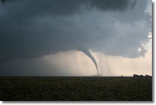
Weather Topic: What are Wall Clouds?
Home - Education - Cloud Types - Wall Clouds
 Next Topic: Altocumulus Clouds
A wall cloud forms underneath the base of a cumulonimbus cloud,
and can be a hotbed for deadly tornadoes.
Wall clouds are formed by air flowing into the cumulonimbus clouds, which can
result in the wall cloud descending from the base of the cumulonimbus cloud, or
rising fractus clouds which join to the base of the storm cloud as the wall cloud
takes shape.
Wall clouds can be very large, and in the Northern Hemisphere they generally
form at the southern edge of cumulonimbus clouds.
Next Topic: Altocumulus Clouds
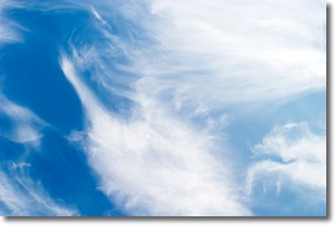
Weather Topic: What are Altostratus Clouds?
Home - Education - Cloud Types - Altostratus Clouds
 Next Topic: Cirrocumulus Clouds
Altostratus clouds form at mid to high-level altitudes
(between 2 and 7 km) and are created by a warm, stable air mass which causes
water vapor
to condense as it rise through the atmosphere. Usually altostratus clouds are
featureless sheets characterized by a uniform color.
In some cases, wind punching through the cloud formation may give it a waved
appearance, called altostratus undulatus. Altostratus clouds
are commonly seen with other cloud formations accompanying them.
Next Topic: Cirrocumulus Clouds
Current conditions powered by WeatherAPI.com


