Weather Alert in New Mexico
Red Flag Warning issued March 14 at 3:10PM MDT until March 15 at 6:00PM MDT by NWS El Paso Tx/Santa Teresa NM
AREAS AFFECTED: Capitan And Sacramento Mountains
DESCRIPTION: ...CRITICAL FIRE WEATHER CONDITIONS THIS WEEKEND FOR LINCOLN NATIONAL FOREST, PORTIONS OF SOUTH CENTRAL NEW MEXICO AND FAR WEST TEXAS... An approaching upper level disturbance will bring increasing west winds to the area this afternoon, and near-critical fire weather conditions to the lowlands. Winds will generally diminish after sunset, but stronger winds are expected to return to the Sacramento Mountains and nearby areas of New Mexico Fire Zone 113 late tonight into Sunday morning, while relative humidity values remain low. The timing of critical fire weather conditions is unusual. Also. rapid drying of fuels over Lincoln National Forest over the past few weeks have increased the risk of fire spread. A strong jet stream will continue crossing the central Rockies on Sunday, leading to more windy conditions in the afternoon, with conditions potentially reaching critical thresholds in the afternoon again, though winds will be on the lower end of critical. * AFFECTED AREA...Fire Weather Zone 113 Capitan and Sacramento Mountains/Lincoln NF/LNZ. * TIMING...3 PM Saturday afternoon through 6 PM Sunday evening. * WINDS...West 20 to 30 with gusts to 40 mph this afternoon. Increasing in the predawn hours Sunday to 30 to 40 mph, with gusts up to 60 mph. * RELATIVE HUMIDITY...As low as 7 percent, with poor overnight recovery. * EXPERIMENTAL RFTI... 4 to 5 Near Critical to Critical. * IMPACTS...any fires that develop will likely spread rapidly. Outdoor burning is not recommended.
INSTRUCTION: A Red Flag Warning means that critical fire weather conditions are either occurring now, or will shortly. A combination of strong winds, low relative humidity, and warm temperatures can contribute to extreme fire behavior.
Want more detail? Get the Complete 7 Day and Night Detailed Forecast!
Current U.S. National Radar--Current
The Current National Weather Radar is shown below with a UTC Time (subtract 5 hours from UTC to get Eastern Time).

National Weather Forecast--Current
The Current National Weather Forecast and National Weather Map are shown below.

National Weather Forecast for Tomorrow
Tomorrow National Weather Forecast and Tomorrow National Weather Map are show below.

North America Water Vapor (Moisture)
This map shows recent moisture content over North America. Bright and colored areas show high moisture (ie, clouds); brown indicates very little moisture present; black indicates no moisture.

Weather Topic: What is Condensation?
Home - Education - Precipitation - Condensation
 Next Topic: Contrails
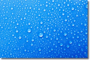
Condensation is the process which creates clouds, and therefore
it is a crucial process in the water cycle.
Condensation is the change of matter from a state of gas into a state of liquid,
and it happens because water molecules release heat into the atmosphere and
become organized into a more closely packed structure, what we might see as
water droplets.
Water is always present in the air around us as a vapor, but it's too small for
us to see. When water undergoes the process of condensation it becomes organized
into visible water droplets. You've probably seen condensation happen before on the
surface of a cold drink!
Next Topic: Contrails
Weather Topic: What are Cumulonimbus Clouds?
Home - Education - Cloud Types - Cumulonimbus Clouds
 Next Topic: Cumulus Clouds
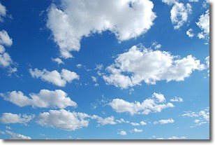
The final form taken by a growing cumulus cloud is the
cumulonimbus cloud, which is very tall and dense.
The tower of a cumulonimbus cloud can soar 23 km into the atmosphere, although
most commonly they stop growing at an altitude of 6 km.
Even small cumulonimbus clouds appear very large in comparison to other cloud types.
They can signal the approach of stormy weather, such as thunderstorms or blizzards.
Next Topic: Cumulus Clouds
Current conditions powered by WeatherAPI.com


