Weather Alert in New Mexico
Red Flag Warning issued March 14 at 3:10PM MDT until March 15 at 6:00PM MDT by NWS El Paso Tx/Santa Teresa NM
AREAS AFFECTED: Capitan And Sacramento Mountains
DESCRIPTION: ...CRITICAL FIRE WEATHER CONDITIONS THIS WEEKEND FOR LINCOLN NATIONAL FOREST, PORTIONS OF SOUTH CENTRAL NEW MEXICO AND FAR WEST TEXAS... An approaching upper level disturbance will bring increasing west winds to the area this afternoon, and near-critical fire weather conditions to the lowlands. Winds will generally diminish after sunset, but stronger winds are expected to return to the Sacramento Mountains and nearby areas of New Mexico Fire Zone 113 late tonight into Sunday morning, while relative humidity values remain low. The timing of critical fire weather conditions is unusual. Also. rapid drying of fuels over Lincoln National Forest over the past few weeks have increased the risk of fire spread. A strong jet stream will continue crossing the central Rockies on Sunday, leading to more windy conditions in the afternoon, with conditions potentially reaching critical thresholds in the afternoon again, though winds will be on the lower end of critical. * AFFECTED AREA...Fire Weather Zone 113 Capitan and Sacramento Mountains/Lincoln NF/LNZ. * TIMING...3 PM Saturday afternoon through 6 PM Sunday evening. * WINDS...West 20 to 30 with gusts to 40 mph this afternoon. Increasing in the predawn hours Sunday to 30 to 40 mph, with gusts up to 60 mph. * RELATIVE HUMIDITY...As low as 7 percent, with poor overnight recovery. * EXPERIMENTAL RFTI... 4 to 5 Near Critical to Critical. * IMPACTS...any fires that develop will likely spread rapidly. Outdoor burning is not recommended.
INSTRUCTION: A Red Flag Warning means that critical fire weather conditions are either occurring now, or will shortly. A combination of strong winds, low relative humidity, and warm temperatures can contribute to extreme fire behavior.
Want more detail? Get the Complete 7 Day and Night Detailed Forecast!
Current U.S. National Radar--Current
The Current National Weather Radar is shown below with a UTC Time (subtract 5 hours from UTC to get Eastern Time).

National Weather Forecast--Current
The Current National Weather Forecast and National Weather Map are shown below.

National Weather Forecast for Tomorrow
Tomorrow National Weather Forecast and Tomorrow National Weather Map are show below.

North America Water Vapor (Moisture)
This map shows recent moisture content over North America. Bright and colored areas show high moisture (ie, clouds); brown indicates very little moisture present; black indicates no moisture.

Weather Topic: What are Nimbostratus Clouds?
Home - Education - Cloud Types - Nimbostratus Clouds
 Next Topic: Precipitation
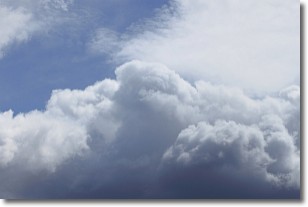
A nimbostratus cloud is similar to a stratus cloud in its formless,
smooth appearance. However, a nimbostratus cloud is darker than a stratus cloud,
because it is thicker.
Unlike a stratus cloud, a nimbostratus cloud typically brings with it the threat
of moderate to heavy precipitation. In some cases, the precipitation may evaporate
before reaching the ground, a phenomenon known as virga.
Next Topic: Precipitation
Weather Topic: What is Rain?
Home - Education - Precipitation - Rain
 Next Topic: Shelf Clouds
Precipitation in the form of water droplets is called rain.
Rain generally has a tendency to fall with less intensity over a greater period
of time, and when rainfall is more severe it is usually less sustained.
Rain is the most common form of precipitation and happens with greater frequency
depending on the season and regional influences. Cities have been shown to have
an observable effect on rainfall, due to an effect called the urban heat island.
Compared to upwind, monthly rainfall between twenty and forty miles downwind of
cities is 30% greater.
Next Topic: Shelf Clouds
Current conditions powered by WeatherAPI.com


