Weather Alert in New Mexico
Fire Weather Watch issued March 14 at 3:10PM MDT until March 15 at 6:00PM MDT by NWS El Paso Tx/Santa Teresa NM
AREAS AFFECTED: Southwest Mountains; South Central Lowlands And Southern Rio Grande Valley; El Paso; Hudspeth
DESCRIPTION: ...CRITICAL FIRE WEATHER CONDITIONS THIS WEEKEND FOR LINCOLN NATIONAL FOREST, PORTIONS OF SOUTH CENTRAL NEW MEXICO AND FAR WEST TEXAS... An approaching upper level disturbance will bring increasing west winds to the area this afternoon, and near-critical fire weather conditions to the lowlands. Winds will generally diminish after sunset, but stronger winds are expected to return to the Sacramento Mountains and nearby areas of New Mexico Fire Zone 113 late tonight into Sunday morning, while relative humidity values remain low. The timing of critical fire weather conditions is unusual. Also. rapid drying of fuels over Lincoln National Forest over the past few weeks have increased the risk of fire spread. A strong jet stream will continue crossing the central Rockies on Sunday, leading to more windy conditions in the afternoon, with conditions potentially reaching critical thresholds in the afternoon again, though winds will be on the lower end of critical. * AFFECTED AREA...Far West Texas, South-Central New Mexico, and the Gila Region in Southwestern New Mexico. Including Texas Fire Weather Zones 055 and 056, and New Mexico Fire Weather Zones 110 and 112. * TIMING...Noon to 6 PM Sunday. * WINDS...Northwest 15 to 25 mph with gusts up to 45 mph. * RELATIVE HUMIDITY...As low as 7 percent. * EXPERIMENTAL RFTI... 3 to 4 Near Critical. * IMPACTS...any fires that develop will likely spread rapidly. Outdoor burning is not recommended.
INSTRUCTION: A Fire Weather Watch means that critical fire weather conditions are forecast to occur. Listen for later forecasts and possible Red Flag Warnings.
Want more detail? Get the Complete 7 Day and Night Detailed Forecast!
Current U.S. National Radar--Current
The Current National Weather Radar is shown below with a UTC Time (subtract 5 hours from UTC to get Eastern Time).

National Weather Forecast--Current
The Current National Weather Forecast and National Weather Map are shown below.

National Weather Forecast for Tomorrow
Tomorrow National Weather Forecast and Tomorrow National Weather Map are show below.

North America Water Vapor (Moisture)
This map shows recent moisture content over North America. Bright and colored areas show high moisture (ie, clouds); brown indicates very little moisture present; black indicates no moisture.

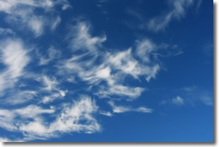
Weather Topic: What are Altostratus Clouds?
Home - Education - Cloud Types - Altostratus Clouds
 Next Topic: Cirrocumulus Clouds
Altostratus clouds form at mid to high-level altitudes
(between 2 and 7 km) and are created by a warm, stable air mass which causes
water vapor
to condense as it rise through the atmosphere. Usually altostratus clouds are
featureless sheets characterized by a uniform color.
In some cases, wind punching through the cloud formation may give it a waved
appearance, called altostratus undulatus. Altostratus clouds
are commonly seen with other cloud formations accompanying them.
Next Topic: Cirrocumulus Clouds
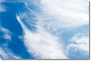
Weather Topic: What are Cirrostratus Clouds?
Home - Education - Cloud Types - Cirrostratus Clouds
 Next Topic: Cirrus Clouds
Cirrostratus clouds are high, thin clouds that form above
20,000 feet and are made mostly of ice crystals. They sometimes look like giant
feathers, horse tails, or curls of hair in the sky.
These clouds are pushed by the jet stream and can move at high speeds reaching
100 mph.
What do they indicate?
They indicate that a precipitation is likely within 24 hours.
Next Topic: Cirrus Clouds
Current conditions powered by WeatherAPI.com


