Weather Alert in Oklahoma
Flood Warning issued August 27 at 2:16PM CDT until August 29 at 8:12PM CDT by NWS Tulsa OK
AREAS AFFECTED: Adair, OK; Cherokee, OK; Delaware, OK
DESCRIPTION: ...The National Weather Service in Tulsa OK has issued a Flood Warning for the following rivers in Oklahoma... Illinois River near Watts affecting Delaware and Adair Counties. Illinois River at Chewey affecting Delaware, Adair and Cherokee Counties. Illinois River near Tahlequah affecting Cherokee County. * WHAT...Minor flooding is forecast. * WHERE...Illinois River at Chewey. * WHEN...From Friday afternoon to Friday evening. * IMPACTS...At 12.0 feet, minor flooding occurs from near Fidler's Bend to near Hanging Rock. Road access near the river to residential homes southeast of Chewey Bridge may be compromised. Water begins to impact 630 Road east of the Cherokee/Adair County line. Floating the river is too hazardous due to strong turbulence. * ADDITIONAL DETAILS... - At 1:15 PM CDT Wednesday the stage was 2.9 feet. - Forecast...The river is expected to rise to a crest of 12.1 feet early Friday afternoon. It will then fall below flood stage by early Friday evening. - Flood stage is 12.0 feet. - http://www.weather.gov/safety/flood
INSTRUCTION: N/A
Want more detail? Get the Complete 7 Day and Night Detailed Forecast!
Current U.S. National Radar--Current
The Current National Weather Radar is shown below with a UTC Time (subtract 5 hours from UTC to get Eastern Time).

National Weather Forecast--Current
The Current National Weather Forecast and National Weather Map are shown below.

National Weather Forecast for Tomorrow
Tomorrow National Weather Forecast and Tomorrow National Weather Map are show below.

North America Water Vapor (Moisture)
This map shows recent moisture content over North America. Bright and colored areas show high moisture (ie, clouds); brown indicates very little moisture present; black indicates no moisture.

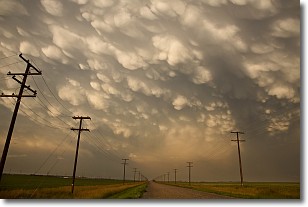
Weather Topic: What are Mammatus Clouds?
Home - Education - Cloud Types - Mammatus Clouds
 Next Topic: Nimbostratus Clouds
A mammatus cloud is a cloud with a unique feature which resembles
a web of pouches hanging along the base of the cloud.
In the United States, mammatus clouds tend to form in the warmer months, commonly
in the Midwest and eastern regions.
While they usually form at the bottom of a cumulonimbis cloud, they can also form
under altostratus, altocumulus, stratocumulus, and cirrus clouds. Mammatus clouds
warn that severe weather is close.
Next Topic: Nimbostratus Clouds
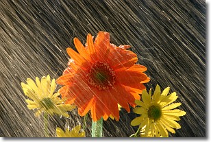
Weather Topic: What is Precipitation?
Home - Education - Precipitation - Precipitation
 Next Topic: Rain
Precipitation can refer to many different forms of water that
may fall from clouds. Precipitation occurs after a cloud has become saturated to
the point where its water particles are more dense than the air below the cloud.
In most cases, precipitation will reach the ground, but it is not uncommon for
precipitation to evaporate before it reaches the earth's surface.
When precipitation evaporates before it contacts the ground it is called Virga.
Graupel, hail, sleet, rain, drizzle, and snow are forms of precipitation, but fog
and mist are not considered precipitation because the water vapor which
constitutes them isn't dense enough to fall to the ground.
Next Topic: Rain
Current conditions powered by WeatherAPI.com


