Weather Alert in Oregon
Red Flag Warning issued August 26 at 7:54AM PDT until August 26 at 9:00PM PDT by NWS Portland OR
AREAS AFFECTED: Northern Willamette National Forest; Southern Willamette National Forest
DESCRIPTION: * AFFECTED AREA...In Oregon, Fire Weather Zone 689 Northern Willamette National Forest and Fire Weather Zone 690 Southern Willamette National Forest. * THUNDERSTORMS...Isolated to scattered thunderstorms. Around a 25% chance of thunderstorms. 10-20% chance of wetting rains in passing storms. * DRY AND UNSTABLE...Unstable conditions with elevated mixing heights may promote pyroconvective activity. * OUTFLOW WINDS...Instantaneous gusts as high as 40 mph. Gusts at these speeds can be observed tens of miles away from the core of the thunderstorm. * IMPACTS...Conditions may be favorable for rapid fire spread which may threaten life and property. Thunderstorm outflow winds may result in unanticipated erratic fire spread. High instability may result in fire growth. Frequent lightning and critically dry fuels may result in fire starts.
INSTRUCTION: A Red Flag Warning means that critical fire weather conditions are either occurring now, or will shortly. A combination of the above conditions can contribute to extreme fire behavior.
Want more detail? Get the Complete 7 Day and Night Detailed Forecast!
Current U.S. National Radar--Current
The Current National Weather Radar is shown below with a UTC Time (subtract 5 hours from UTC to get Eastern Time).

National Weather Forecast--Current
The Current National Weather Forecast and National Weather Map are shown below.

National Weather Forecast for Tomorrow
Tomorrow National Weather Forecast and Tomorrow National Weather Map are show below.

North America Water Vapor (Moisture)
This map shows recent moisture content over North America. Bright and colored areas show high moisture (ie, clouds); brown indicates very little moisture present; black indicates no moisture.

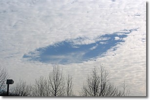
Weather Topic: What are Hole Punch Clouds?
Home - Education - Cloud Types - Hole Punch Clouds
 Next Topic: Mammatus Clouds
A hole punch cloud is an unusual occurrence when a disk-shaped
hole appears in a cirrostratus, cirrocumulus, or altocumulus cloud.
When part of the cloud forms ice crystals, water droplets in the surrounding area
of the cloud evaporate. The effect of this process produces a large elliptical
gap in the cloud. The hole punch cloud formation is rare, but it is not specific
to any geographic area.
Other names which have been used to describe this phenomena include fallstreak hole,
skypunch, and cloud hole.
Next Topic: Mammatus Clouds
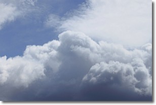
Weather Topic: What are Nimbostratus Clouds?
Home - Education - Cloud Types - Nimbostratus Clouds
 Next Topic: Precipitation
A nimbostratus cloud is similar to a stratus cloud in its formless,
smooth appearance. However, a nimbostratus cloud is darker than a stratus cloud,
because it is thicker.
Unlike a stratus cloud, a nimbostratus cloud typically brings with it the threat
of moderate to heavy precipitation. In some cases, the precipitation may evaporate
before reaching the ground, a phenomenon known as virga.
Next Topic: Precipitation
Current conditions powered by WeatherAPI.com


