Weather Alert in Michigan
Blizzard Warning issued March 15 at 6:20AM EDT until March 16 at 8:00PM EDT by NWS Marquette MI
AREAS AFFECTED: Ontonagon; Gogebic; Southern Houghton
DESCRIPTION: * WHAT...Blizzard conditions. Total snow accumulations between 1 and 2 feet. Winds gusting as high as 45 mph. * WHERE...Gogebic, Ontonagon, and Southern Houghton Counties. * WHEN...Until 8 PM EDT /7 PM CDT/ Monday. * IMPACTS...Travel will be treacherous and potentially life-threatening. Widespread blowing snow and heavy snowfall rates will significantly reduce visibility. Gusty winds could bring down tree branches and result in power outages. * ADDITIONAL DETAILS...Heavy snowfall rates of 1 to 2 inches per hour are expected much of the day today. Strongest winds late this afternoon into Monday.
INSTRUCTION: Travel should be restricted to emergencies only. If you must travel, have a winter survival kit with you. If you get stranded, stay with your vehicle. Persons should consider delaying all travel. Motorists should use extreme caution if travel is absolutely necessary.
Want more detail? Get the Complete 7 Day and Night Detailed Forecast!
Current U.S. National Radar--Current
The Current National Weather Radar is shown below with a UTC Time (subtract 5 hours from UTC to get Eastern Time).

National Weather Forecast--Current
The Current National Weather Forecast and National Weather Map are shown below.

National Weather Forecast for Tomorrow
Tomorrow National Weather Forecast and Tomorrow National Weather Map are show below.

North America Water Vapor (Moisture)
This map shows recent moisture content over North America. Bright and colored areas show high moisture (ie, clouds); brown indicates very little moisture present; black indicates no moisture.

Weather Topic: What is Freezing Rain?
Home - Education - Precipitation - Freezing Rain
 Next Topic: Graupel
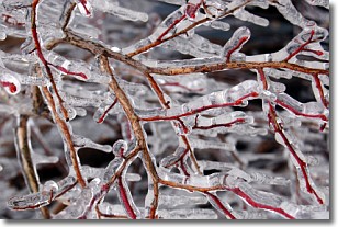
Freezing rain is a condition where precipitation which has fallen in the form of
water droplets reaches temperatures which are below freezing and freezes upon
coming into contact
with surface objects. The result of this precipitation is a glaze of ice which
can be damaging to plants and man-made structures. A severe onset of freezing
rain which results in a very thick glaze of ice is known as an ice storm.
Next Topic: Graupel
Weather Topic: What is Hail?
Home - Education - Precipitation - Hail
 Next Topic: Hole Punch Clouds
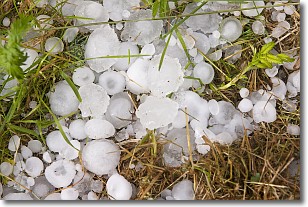
Hail is a form of precipitation which is recognized by large solid balls or
clumps of ice. Hail is created by thunderstorm clouds with strong updrafts of wind.
As the hailstones remain in the updraft, ice is deposited onto them until their
weight becomes heavy enough for them to fall to the earth's surface.
Hail storms can cause significant damage to crops, aircrafts, and man-made structures,
despite the fact that the duration is usually less than ten minutes.
Next Topic: Hole Punch Clouds
Current conditions powered by WeatherAPI.com


