Weather Alert in Wisconsin
Blizzard Warning issued March 15 at 2:13AM CDT until March 16 at 4:00PM CDT by NWS Green Bay WI
AREAS AFFECTED: Wood; Portage; Waupaca; Waushara
DESCRIPTION: * WHAT...Heavy snow expected. The snow will mix with or change over to sleet or freezing rain at times today. Total snow and sleet accumulations between 13 and 22 inches, with the lowest amounts toward Wautoma. Ice accumulations between one and two tenths of an inch. Winds gusting as high as 50 mph will result in considerable blowing and drifting snow, resulting in blizzard conditions this afternoon into Monday. * WHERE...Portage, Waushara, Wood, and Waupaca Counties. * WHEN...For the Winter Storm Warning, until 10 AM CDT this morning. For the Blizzard Warning, from 10 AM this morning to 4 PM CDT Monday. * IMPACTS...Travel will become very difficult to impossible with whiteout conditions. Gusty winds could bring down tree branches and cause power outages. The Monday morning commute will be severely impacted.
INSTRUCTION: If you must travel, keep an extra flashlight, food, and water in your vehicle in case of an emergency. The latest road conditions for the state you are calling from can be obtained by calling 5 1 1. People should consider delaying all travel. If travel is absolutely necessary, drive with extreme caution. Consider taking a winter storm kit along with you, including such items as tire chains, booster cables, flashlight, shovel, blankets and extra clothing. Also take water, a first aid kit, and anything else that would help you survive in case you become stranded.
Want more detail? Get the Complete 7 Day and Night Detailed Forecast!
Current U.S. National Radar--Current
The Current National Weather Radar is shown below with a UTC Time (subtract 5 hours from UTC to get Eastern Time).

National Weather Forecast--Current
The Current National Weather Forecast and National Weather Map are shown below.

National Weather Forecast for Tomorrow
Tomorrow National Weather Forecast and Tomorrow National Weather Map are show below.

North America Water Vapor (Moisture)
This map shows recent moisture content over North America. Bright and colored areas show high moisture (ie, clouds); brown indicates very little moisture present; black indicates no moisture.

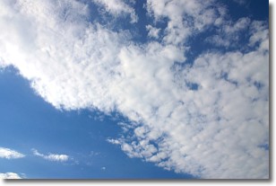
Weather Topic: What are Stratus Clouds?
Home - Education - Cloud Types - Stratus Clouds
 Next Topic: Wall Clouds
Stratus clouds are similar to altostratus clouds, but form at a
lower altitude and are identified by their fog-like appearance, lacking the
distinguishing features of most clouds.
Stratus clouds are wider than most clouds, and their base has a smooth, uniform
look which is lighter in color than a nimbostratus cloud.
The presence of a stratus cloud indicates the possibility of minor precipitation,
such as drizzle, but heavier precipitation does not typically arrive in the form
of a stratus cloud.
Next Topic: Wall Clouds
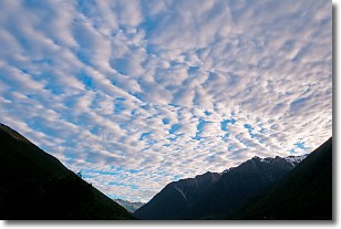
Weather Topic: What are Altocumulus Clouds?
Home - Education - Cloud Types - Altocumulus Clouds
 Next Topic: Altostratus Clouds
Similar to cirrocumulus clouds, altocumulus clouds are
characterized by cloud patches. They are distinguished by larger cloudlets
than cirrocumulus clouds but are still smaller than stratocumulus clouds.
Altocumulus clouds most commonly form in middle altitudes (between 2 and 5 km)
and may resemble, at times, the shape of a flying saucer.
These uncommon formations, called altocumulus lenticularis, are created by uplift
in the atmosphere and are most often seen in close proximity to mountains.
Next Topic: Altostratus Clouds
Current conditions powered by WeatherAPI.com


