Weather Alert in Wisconsin
Blizzard Warning issued March 15 at 2:13AM CDT until March 16 at 4:00PM CDT by NWS Green Bay WI
AREAS AFFECTED: Kewaunee; Manitowoc
DESCRIPTION: * WHAT...Heavy snow expected. The snow will mix with or change over to sleet, freezing rain, and rain at times today. Total snow and sleet accumulations between 10 and 18 inches, with the lowest amounts in southern Manitowoc County. Ice accumulations between one and two tenths of an inch. Winds gusting as high as 50 mph will result in considerable blowing and drifting snow and blizzard conditions this evening into Monday. * WHERE...Manitowoc and Kewaunee Counties. * WHEN...For the Winter Storm Warning, until 7 PM CDT this evening. For the Blizzard Warning, from 7 PM this evening to 4 PM CDT Monday. * IMPACTS...Travel could be very difficult to impossible with potential for whiteout conditions. Gusty winds could bring down tree branches and cause power outages. The Monday morning commute will be severely impacted.
INSTRUCTION: Travel should be restricted to emergencies only. If you must travel, have a winter survival kit with you. If you get stranded, stay with your vehicle. The latest road conditions for the state you are calling from can be obtained by calling 5 1 1. People should consider delaying all travel. Motorists should use extreme caution if travel is absolutely necessary.
Want more detail? Get the Complete 7 Day and Night Detailed Forecast!
Current U.S. National Radar--Current
The Current National Weather Radar is shown below with a UTC Time (subtract 5 hours from UTC to get Eastern Time).

National Weather Forecast--Current
The Current National Weather Forecast and National Weather Map are shown below.

National Weather Forecast for Tomorrow
Tomorrow National Weather Forecast and Tomorrow National Weather Map are show below.

North America Water Vapor (Moisture)
This map shows recent moisture content over North America. Bright and colored areas show high moisture (ie, clouds); brown indicates very little moisture present; black indicates no moisture.

Weather Topic: What is Graupel?
Home - Education - Precipitation - Graupel
 Next Topic: Hail
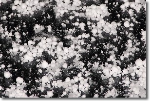
Graupel is a form of precipitation that is created by atmospheric conditions
which cause supercooled water droplets to contact snow crystals and freeze to
their surface.
Sometimes known as soft hail or snow pellets, graupel is delicate and easily
destroyed by touch. Whereas hail usually falls during severe weather, graupel
doesn't require such conditions to form, and can form in mild precipitation
similar to situations which produce snowfall.
Next Topic: Hail
Weather Topic: What are Hole Punch Clouds?
Home - Education - Cloud Types - Hole Punch Clouds
 Next Topic: Mammatus Clouds
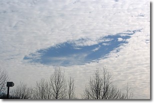
A hole punch cloud is an unusual occurrence when a disk-shaped
hole appears in a cirrostratus, cirrocumulus, or altocumulus cloud.
When part of the cloud forms ice crystals, water droplets in the surrounding area
of the cloud evaporate. The effect of this process produces a large elliptical
gap in the cloud. The hole punch cloud formation is rare, but it is not specific
to any geographic area.
Other names which have been used to describe this phenomena include fallstreak hole,
skypunch, and cloud hole.
Next Topic: Mammatus Clouds
Current conditions powered by WeatherAPI.com


