Weather Alert in Texas
Red Flag Warning issued March 14 at 12:06PM CDT until March 15 at 9:00PM CDT by NWS Fort Worth TX
AREAS AFFECTED: Montague; Cooke; Young; Jack; Wise; Denton; Stephens; Palo Pinto; Parker; Tarrant; Dallas; Eastland; Erath; Hood; Somervell; Johnson; Ellis; Comanche; Mills; Hamilton; Bosque; Hill; Lampasas; Coryell; Bell; McLennan; Falls; Milam
DESCRIPTION: ...A Red Flag Warning is in effect Sunday afternoon and evening for western portions of North and Central Texas... The National Weather Service in Fort Worth has issued a Red Flag Warning for near-critical to critical fire weather conditions, which is in effect from noon to 9 PM CDT Sunday. The Fire Weather Watch is no longer in effect. * AFFECTED AREA...Fire Weather Zone 091 Montague, Fire Weather Zone 092 Cooke, Fire Weather Zone 100 Young, Fire Weather Zone 101 Jack, Fire Weather Zone 102 Wise, Fire Weather Zone 103 Denton, Fire Weather Zone 115 Stephens, Fire Weather Zone 116 Palo Pinto, Fire Weather Zone 117 Parker, Fire Weather Zone 118 Tarrant, Fire Weather Zone 119 Dallas, Fire Weather Zone 129 Eastland, Fire Weather Zone 130 Erath, Fire Weather Zone 131 Hood, Fire Weather Zone 132 Somervell, Fire Weather Zone 133 Johnson, Fire Weather Zone 134 Ellis, Fire Weather Zone 141 Comanche, Fire Weather Zone 142 Mills, Fire Weather Zone 143 Hamilton, Fire Weather Zone 144 Bosque, Fire Weather Zone 145 Hill, Fire Weather Zone 156 Lampasas, Fire Weather Zone 157 Coryell, Fire Weather Zone 158 Bell, Fire Weather Zone 159 McLennan, Fire Weather Zone 160 Falls and Fire Weather Zone 174 Milam. * WINDS...Northwest at 25 to 35 mph with gusts up to 40 to 50 mph. * RELATIVE HUMIDITY...As low as 19 percent. * TEMPERATURES...Up to 87. * HIGHEST THREAT...is located near and west of Highway 281. * IMPACTS...Any fires that develop will likely spread rapidly. Outdoor burning is not recommended.
INSTRUCTION: A Red Flag Warning means that extreme fire weather conditions are either occurring now, or will shortly. A combination of strong winds, low relative humidity, and dry vegetation can contribute to extreme fire behavior. Avoid all outside burning and welding today. Do not toss lit cigarette butts outside. Report wildfires to the nearest fire department or law enforcement office.
Want more detail? Get the Complete 7 Day and Night Detailed Forecast!
Current U.S. National Radar--Current
The Current National Weather Radar is shown below with a UTC Time (subtract 5 hours from UTC to get Eastern Time).

National Weather Forecast--Current
The Current National Weather Forecast and National Weather Map are shown below.

National Weather Forecast for Tomorrow
Tomorrow National Weather Forecast and Tomorrow National Weather Map are show below.

North America Water Vapor (Moisture)
This map shows recent moisture content over North America. Bright and colored areas show high moisture (ie, clouds); brown indicates very little moisture present; black indicates no moisture.

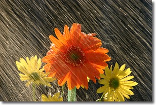
Weather Topic: What is Precipitation?
Home - Education - Precipitation - Precipitation
 Next Topic: Rain
Precipitation can refer to many different forms of water that
may fall from clouds. Precipitation occurs after a cloud has become saturated to
the point where its water particles are more dense than the air below the cloud.
In most cases, precipitation will reach the ground, but it is not uncommon for
precipitation to evaporate before it reaches the earth's surface.
When precipitation evaporates before it contacts the ground it is called Virga.
Graupel, hail, sleet, rain, drizzle, and snow are forms of precipitation, but fog
and mist are not considered precipitation because the water vapor which
constitutes them isn't dense enough to fall to the ground.
Next Topic: Rain
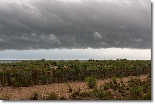
Weather Topic: What are Shelf Clouds?
Home - Education - Cloud Types - Shelf Clouds
 Next Topic: Sleet
A shelf cloud is similar to a wall cloud, but forms at the front
of a storm cloud, instead of at the rear, where wall clouds form.
A shelf cloud is caused by a series of events set into motion by the advancing
storm; first, cool air settles along the ground where precipitation has just fallen.
As the cool air is brought in, the warmer air is displaced, and rises above it,
because it is less dense. When the warmer air reaches the bottom of the storm cloud,
it begins to cool again, and the resulting condensation is a visible shelf cloud.
Next Topic: Sleet
Current conditions powered by WeatherAPI.com


