Weather Alert in Alabama
Freeze Warning issued March 14 at 10:24PM CDT until March 17 at 10:00AM CDT by NWS Birmingham AL
AREAS AFFECTED: Marion; Lamar; Fayette; Winston; Walker; Blount; Etowah; Calhoun; Cherokee; Cleburne; Pickens; Tuscaloosa; Jefferson; Shelby; St. Clair; Talladega; Clay; Randolph; Sumter; Greene; Hale; Perry; Bibb; Chilton; Coosa; Tallapoosa; Chambers; Marengo; Dallas; Autauga; Lowndes; Elmore; Montgomery; Macon; Bullock; Lee; Russell; Pike; Barbour
DESCRIPTION: * WHAT...For the Wind Advisory, southwest winds 10 to 20 mph with gusts up to 40 mph expected. For the Freeze Warning, sub-freezing temperatures as low as 24 expected. * WHERE...A portion of central Alabama. * WHEN...For the Wind Advisory, from 1 PM Sunday to 1 PM CDT Monday. For the Freeze Warning, from 10 PM Monday to 10 AM CDT Tuesday. * IMPACTS...Gusty winds will blow around unsecured objects. Trees could be blown down and a few power outages may result. Frost and freeze conditions could kill crops, other sensitive vegetation and possibly damage unprotected outdoor plumbing.
INSTRUCTION: Winds this strong can make driving difficult, especially for high profile vehicles. Use extra caution. Secure outdoor objects. Take steps now to protect tender plants from the cold. To prevent freezing and possible bursting of pipes they should be wrapped, drained, or allowed to drip slowly. Those that have in ground sprinkler systems should drain them and cover above ground pipes to protect them from freezing.
Want more detail? Get the Complete 7 Day and Night Detailed Forecast!
Current U.S. National Radar--Current
The Current National Weather Radar is shown below with a UTC Time (subtract 5 hours from UTC to get Eastern Time).

National Weather Forecast--Current
The Current National Weather Forecast and National Weather Map are shown below.

National Weather Forecast for Tomorrow
Tomorrow National Weather Forecast and Tomorrow National Weather Map are show below.

North America Water Vapor (Moisture)
This map shows recent moisture content over North America. Bright and colored areas show high moisture (ie, clouds); brown indicates very little moisture present; black indicates no moisture.

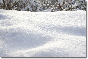
Weather Topic: What is Snow?
Home - Education - Precipitation - Snow
 Next Topic: Stratocumulus Clouds
Snow is precipitation taking the form of ice crystals. Each ice crystal, or snowflake,
has unique characteristics, but all of them grow in a hexagonal structure.
Snowfall can last for sustained periods of time and result in significant buildup
of snow on the ground.
On the earth's surface, snow starts out light and powdery, but as it begins to melt
it tends to become more granular, producing small bits of ice which have the consistency of
sand. After several cycles of melting and freezing, snow can become very dense
and ice-like, commonly known as snow pack.
Next Topic: Stratocumulus Clouds
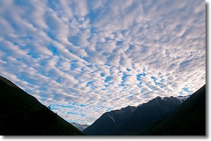
Weather Topic: What are Stratus Clouds?
Home - Education - Cloud Types - Stratus Clouds
 Next Topic: Wall Clouds
Stratus clouds are similar to altostratus clouds, but form at a
lower altitude and are identified by their fog-like appearance, lacking the
distinguishing features of most clouds.
Stratus clouds are wider than most clouds, and their base has a smooth, uniform
look which is lighter in color than a nimbostratus cloud.
The presence of a stratus cloud indicates the possibility of minor precipitation,
such as drizzle, but heavier precipitation does not typically arrive in the form
of a stratus cloud.
Next Topic: Wall Clouds
Current conditions powered by WeatherAPI.com


