Weather Alert in Oregon
Flood Advisory issued March 14 at 1:48PM PDT until March 15 at 12:00PM PDT by NWS Pendleton OR
AREAS AFFECTED: Umatilla, OR; Union, OR; Wallowa, OR; Columbia, WA; Walla Walla, WA
DESCRIPTION: * WHAT...Flooding caused by runoff and snowmelt continues. * WHERE...Portions of northeast Oregon, including the following counties, Umatilla, Union and Wallowa and southeast Washington, including the following counties, Columbia and Walla Walla. * WHEN...Until noon PDT Sunday. * IMPACTS...Minor flooding in low-lying and poor drainage areas. Rises in small streams and normally dry arroyos. Overflowing poor drainage areas. River or stream flows are elevated. * ADDITIONAL DETAILS... - At 145 PM PDT, emergency management reported river flooding along area rivers and streams. Minor flooding is ongoing or is imminent. - Area rivers and streams is the most likely place to experience minor flooding. Flooding impacts will continue, but no additional rainfall is expected. - Some locations that will experience flooding include... Walla Walla, Pendleton, La Grande, Dayton, Meacham, College Place, Milton-Freewater, Waitsburg, Athena, Weston, Adams, Prescott, Helix, Starbuck, Bingham Springs, Tollgate, Spout Springs, Garrett, Gibbon and Dixie. - http://www.weather.gov/safety/flood
INSTRUCTION: Turn around, don't drown when encountering flooded roads. Most flood deaths occur in vehicles. Be aware of your surroundings and do not drive on flooded roads. In hilly terrain there are hundreds of low water crossings which are potentially dangerous in heavy rain. Do not attempt to cross flooded roads. Find an alternate route.
Want more detail? Get the Complete 7 Day and Night Detailed Forecast!
Current U.S. National Radar--Current
The Current National Weather Radar is shown below with a UTC Time (subtract 5 hours from UTC to get Eastern Time).

National Weather Forecast--Current
The Current National Weather Forecast and National Weather Map are shown below.

National Weather Forecast for Tomorrow
Tomorrow National Weather Forecast and Tomorrow National Weather Map are show below.

North America Water Vapor (Moisture)
This map shows recent moisture content over North America. Bright and colored areas show high moisture (ie, clouds); brown indicates very little moisture present; black indicates no moisture.

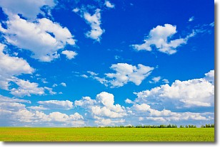
Weather Topic: What are Cumulus Clouds?
Home - Education - Cloud Types - Cumulus Clouds
 Next Topic: Drizzle
Cumulus clouds are fluffy and textured with rounded tops, and
may have flat bottoms. The border of a cumulus cloud
is clearly defined, and can have the appearance of cotton or cauliflower.
Cumulus clouds form at low altitudes (rarely above 2 km) but can grow very tall,
becoming cumulus congestus and possibly the even taller cumulonimbus clouds.
When cumulus clouds become taller, they have a greater chance of producing precipitation.
Next Topic: Drizzle
Weather Topic: What is Evaporation?
Home - Education - Precipitation - Evaporation
 Next Topic: Fog
Evaporation is the process which returns water from the earth
back to the atmosphere, and is another crucial process in the water cycle.
Evaporation is the transformation of liquid into gas, and it happens because
molecules are excited by the application of energy and turn into vapor.
In order for water to evaporate it has to be on the surface of a body of water.
Next Topic: Fog
Current conditions powered by WeatherAPI.com


