Weather Alert in Michigan
Winter Weather Advisory issued March 14 at 1:03PM EDT until March 15 at 11:00AM EDT by NWS Detroit/Pontiac MI
AREAS AFFECTED: Midland; Bay; Huron; Saginaw; Tuscola; Sanilac
DESCRIPTION: * WHAT...Mixed precipitation expected. Total snow and sleet accumulations between 1 and 3 inches and ice accumulations up to one tenth inch. Winds gusting as high as 35 mph. * WHERE...The Tri Cities and northern Thumb portions of southeast Michigan. * WHEN...From midnight tonight to 11 AM Sunday. * IMPACTS...Untreated roads, especially bridges and overpasses, become slick and hazardous as temperatures drop into the upper 20s after midnight. * ADDITIONAL DETAILS...A burst of snow after midnight becomes mixed with sleet or snow pellets and freezing rain toward sunrise. The wintry mix becomes all rain before ending mid to late morning.
INSTRUCTION: Allow extra travel time Sunday morning. You can obtain the latest road conditions from the MDOT Michigan Drive Map.
Want more detail? Get the Complete 7 Day and Night Detailed Forecast!
Current U.S. National Radar--Current
The Current National Weather Radar is shown below with a UTC Time (subtract 5 hours from UTC to get Eastern Time).

National Weather Forecast--Current
The Current National Weather Forecast and National Weather Map are shown below.

National Weather Forecast for Tomorrow
Tomorrow National Weather Forecast and Tomorrow National Weather Map are show below.

North America Water Vapor (Moisture)
This map shows recent moisture content over North America. Bright and colored areas show high moisture (ie, clouds); brown indicates very little moisture present; black indicates no moisture.

Weather Topic: What is Graupel?
Home - Education - Precipitation - Graupel
 Next Topic: Hail
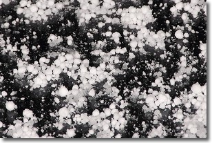
Graupel is a form of precipitation that is created by atmospheric conditions
which cause supercooled water droplets to contact snow crystals and freeze to
their surface.
Sometimes known as soft hail or snow pellets, graupel is delicate and easily
destroyed by touch. Whereas hail usually falls during severe weather, graupel
doesn't require such conditions to form, and can form in mild precipitation
similar to situations which produce snowfall.
Next Topic: Hail
Weather Topic: What are Hole Punch Clouds?
Home - Education - Cloud Types - Hole Punch Clouds
 Next Topic: Mammatus Clouds
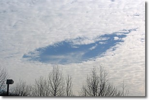
A hole punch cloud is an unusual occurrence when a disk-shaped
hole appears in a cirrostratus, cirrocumulus, or altocumulus cloud.
When part of the cloud forms ice crystals, water droplets in the surrounding area
of the cloud evaporate. The effect of this process produces a large elliptical
gap in the cloud. The hole punch cloud formation is rare, but it is not specific
to any geographic area.
Other names which have been used to describe this phenomena include fallstreak hole,
skypunch, and cloud hole.
Next Topic: Mammatus Clouds
Current conditions powered by WeatherAPI.com


