Weather Alert in Washington
Air Quality Alert issued September 3 at 1:45PM PDT by NWS Pendleton OR
AREAS AFFECTED: Benton, WA; Columbia, WA; Franklin, WA; Kittitas, WA; Klickitat, WA; Walla Walla, WA; Yakima, WA
DESCRIPTION: The Washington State Department of Ecology and/or the Yakima Regional Clean Air Agency has issued an Air Quality Alert for Kittitas, Yakima, Klickitat, Benton, Walla Walla, Franklin, and Columbia counties until further notice due to current and expected wildfire smoke from regional wildfires. When air quality is unhealthy, everyone should reduce exposure. Limit time outside, avoid strenuous outdoor activity, and follow tips for cleaner indoor air. Hot temperatures will increase the risk of heat- related illnesses. Drink plenty of fluids, stay in an air- conditioned room, stay out of the sun, and check up on relatives and neighbors. Information about air quality from the Washington Department of Ecology Web site is available at http://www.ecy.wa.gov/air.html or call 360-407-6000.Information about air quality is on the Yakima Regional Clean Air Agency Web site at http://www.yakimacleanair.org or call 509-834-2050.
INSTRUCTION: N/A
Want more detail? Get the Complete 7 Day and Night Detailed Forecast!
Current U.S. National Radar--Current
The Current National Weather Radar is shown below with a UTC Time (subtract 5 hours from UTC to get Eastern Time).

National Weather Forecast--Current
The Current National Weather Forecast and National Weather Map are shown below.

National Weather Forecast for Tomorrow
Tomorrow National Weather Forecast and Tomorrow National Weather Map are show below.

North America Water Vapor (Moisture)
This map shows recent moisture content over North America. Bright and colored areas show high moisture (ie, clouds); brown indicates very little moisture present; black indicates no moisture.

Weather Topic: What is Evaporation?
Home - Education - Precipitation - Evaporation
 Next Topic: Fog
Evaporation is the process which returns water from the earth
back to the atmosphere, and is another crucial process in the water cycle.
Evaporation is the transformation of liquid into gas, and it happens because
molecules are excited by the application of energy and turn into vapor.
In order for water to evaporate it has to be on the surface of a body of water.
Next Topic: Fog
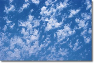
Weather Topic: What are Fractus Clouds?
Home - Education - Cloud Types - Fractus Clouds
 Next Topic: Freezing Rain
A fractus cloud (scud) is a fragmented, tattered cloud which has
likely been sheared off of another cloud. They are accessory clouds, meaning they
develop from parent clouds, and are named in a way which describes the original
cloud which contained them.
Fractus clouds which have originated from cumulus clouds are referred to as
cumulus fractus, while fractus clouds which have originated from stratus clouds
are referred to as stratus fractus. Under certain conditions a fractus cloud might
merge with another cloud, or develop into a cumulus cloud, but usually a
fractus cloud seen by itself will dissipate rapidly.
They are often observed on the leading and trailing edges of storm clouds,
and are a display of wind activity.
Next Topic: Freezing Rain
Current conditions powered by WeatherAPI.com


