Weather Alert in New Mexico
Flood Watch issued August 30 at 12:53AM MDT until August 31 at 6:00AM MDT by NWS Albuquerque NM
AREAS AFFECTED: Curry County; Roosevelt County; De Baca County; Chaves County Plains; Eastern Lincoln County; Southwest Chaves County
DESCRIPTION: * WHAT...Flash flooding caused by excessive rainfall continues to be possible. * WHERE...Portions of central, east central, and southeast New Mexico, including the following areas, in central New Mexico, Eastern Lincoln County. In east central New Mexico, Curry County, De Baca County and Roosevelt County. In southeast New Mexico, Chaves County Plains and Southwest Chaves County. * WHEN...From noon MDT today through late tonight. * IMPACTS...Excessive runoff may result in flooding of rivers, creeks, streams, and other low-lying and flood-prone locations. Flooding may occur in poor drainage and urban areas. Extensive street flooding and flooding of creeks and rivers are possible. * ADDITIONAL DETAILS... - Above normal atmospheric moisture and impressive instability will combine to produce torrential rain producing storms Saturday afternoon and night. Rainfall rates in excess of 3 inches per hour are likely. This heavy rainfall will fall over already saturated grounds from Friday's heavy rainfall, increasing the flash flood threat. - http://www.weather.gov/safety/flood
INSTRUCTION: You should monitor later forecasts and be prepared to take action should Flash Flood Warnings be issued.
Want more detail? Get the Complete 7 Day and Night Detailed Forecast!
Current U.S. National Radar--Current
The Current National Weather Radar is shown below with a UTC Time (subtract 5 hours from UTC to get Eastern Time).

National Weather Forecast--Current
The Current National Weather Forecast and National Weather Map are shown below.

National Weather Forecast for Tomorrow
Tomorrow National Weather Forecast and Tomorrow National Weather Map are show below.

North America Water Vapor (Moisture)
This map shows recent moisture content over North America. Bright and colored areas show high moisture (ie, clouds); brown indicates very little moisture present; black indicates no moisture.

Weather Topic: What are Wall Clouds?
Home - Education - Cloud Types - Wall Clouds
 Next Topic: Altocumulus Clouds
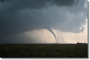
A wall cloud forms underneath the base of a cumulonimbus cloud,
and can be a hotbed for deadly tornadoes.
Wall clouds are formed by air flowing into the cumulonimbus clouds, which can
result in the wall cloud descending from the base of the cumulonimbus cloud, or
rising fractus clouds which join to the base of the storm cloud as the wall cloud
takes shape.
Wall clouds can be very large, and in the Northern Hemisphere they generally
form at the southern edge of cumulonimbus clouds.
Next Topic: Altocumulus Clouds
Weather Topic: What are Altostratus Clouds?
Home - Education - Cloud Types - Altostratus Clouds
 Next Topic: Cirrocumulus Clouds
Altostratus clouds form at mid to high-level altitudes
(between 2 and 7 km) and are created by a warm, stable air mass which causes
water vapor
to condense as it rise through the atmosphere. Usually altostratus clouds are
featureless sheets characterized by a uniform color.
In some cases, wind punching through the cloud formation may give it a waved
appearance, called altostratus undulatus. Altostratus clouds
are commonly seen with other cloud formations accompanying them.
Next Topic: Cirrocumulus Clouds
Current conditions powered by WeatherAPI.com


