Weather Alert in Wisconsin
Blizzard Warning issued March 15 at 3:04AM CDT until March 16 at 7:00AM CDT by NWS Twin Cities/Chanhassen MN
AREAS AFFECTED: Barron; Rusk; St. Croix; Pierce; Dunn; Pepin; Chippewa; Eau Claire
DESCRIPTION: ...VERY HEAVY SNOW HAS DEVELOPED ACROSS SOUTHERN MINNESOTA AND IS EXPECTED TO EXPAND INTO WESTERN WISCONSIN THIS MORNING... ...WINDS WILL INCREASE SIGNIFICANTLY THIS MORNING WITH WIDESPREAD BLOWING SNOW AND BLIZZARD CONDITIONS THIS AFTERNOON AND TONIGHT... .Heavy snow across southern Minnesota will expand northeast into west central Wisconsin this morning. Additional accumulations of 12 to 18 inches are expected in this corridor. Snowfall rates of 2 to 3 inches per hour are possible through mid morning. Lighter snow to the northwest will persist through the morning, then taper off from northwest to southeast later this afternoon and evening. Travel conditions will continue to deteriorate today. Despite the snow tapering off gradually this afternoon, northwest winds will increase to 30 to 40 mph. Some gusts near 60 mph are expected across the Minnesota River Valley. The combination of falling snow, blowing snow, and gusty winds will reduce visibility and create blizzard conditions into tonight. * WHAT...Blizzard conditions. Additional snow accumulations between 13 and 20 inches. Winds gusting as high as 50 mph. * WHERE...Barron, Rusk, Chippewa, Dunn, Eau Claire, Pepin, Pierce, and St. Croix Counties. * WHEN...Until 7 AM CDT Monday. * IMPACTS...Travel could be very difficult to impossible. Widespread blowing snow could significantly reduce visibility. The hazardous conditions will impact the Monday morning commute. Gusty winds could bring down tree branches.
INSTRUCTION: Travel should be restricted to emergencies only. If you must travel, have a winter survival kit with you. If you get stranded, stay with your vehicle. In Minnesota, call 5 1 1 or visit 511mn.org for road conditions. In Wisconsin, call 5 1 1 or visit 511wi.gov for road conditions.
Want more detail? Get the Complete 7 Day and Night Detailed Forecast!
Current U.S. National Radar--Current
The Current National Weather Radar is shown below with a UTC Time (subtract 5 hours from UTC to get Eastern Time).

National Weather Forecast--Current
The Current National Weather Forecast and National Weather Map are shown below.

National Weather Forecast for Tomorrow
Tomorrow National Weather Forecast and Tomorrow National Weather Map are show below.

North America Water Vapor (Moisture)
This map shows recent moisture content over North America. Bright and colored areas show high moisture (ie, clouds); brown indicates very little moisture present; black indicates no moisture.

Weather Topic: What are Altostratus Clouds?
Home - Education - Cloud Types - Altostratus Clouds
 Next Topic: Cirrocumulus Clouds
Altostratus clouds form at mid to high-level altitudes
(between 2 and 7 km) and are created by a warm, stable air mass which causes
water vapor
to condense as it rise through the atmosphere. Usually altostratus clouds are
featureless sheets characterized by a uniform color.
In some cases, wind punching through the cloud formation may give it a waved
appearance, called altostratus undulatus. Altostratus clouds
are commonly seen with other cloud formations accompanying them.
Next Topic: Cirrocumulus Clouds
Weather Topic: What are Cirrostratus Clouds?
Home - Education - Cloud Types - Cirrostratus Clouds
 Next Topic: Cirrus Clouds
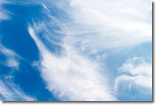
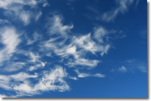
Cirrostratus clouds are high, thin clouds that form above
20,000 feet and are made mostly of ice crystals. They sometimes look like giant
feathers, horse tails, or curls of hair in the sky.
These clouds are pushed by the jet stream and can move at high speeds reaching
100 mph.
What do they indicate?
They indicate that a precipitation is likely within 24 hours.
Next Topic: Cirrus Clouds
Current conditions powered by WeatherAPI.com


