Weather Alert in Illinois
Flood Warning issued March 14 at 12:03PM CDT until March 16 at 1:00AM CDT by NWS Paducah KY
AREAS AFFECTED: Gallatin, IL; Hardin, IL; Crittenden, KY; Union, KY
DESCRIPTION: ...The Flood Warning is extended for the following rivers in Kentucky...Illinois... Ohio River at Shawneetown affecting Hardin, Gallatin, Union and Crittenden Counties. .Minor flooding is occurring on the Ohio River due to recent heavy rainfall across the region. At Shawneetown, the river is forecast to remain above flood stage until Monday morning. For the Ohio River...including Owensboro, Newburgh Dam, Evansville, Henderson, Mount Vernon, J.T. Myers Dam, Shawneetown, Golconda, Smithland Dam, Paducah, Olmsted Lock and Dam, Cairo...Minor flooding is forecast. * WHAT...Minor flooding is occurring and minor flooding is forecast. * WHERE...Ohio River at Shawneetown. * WHEN...Until early Monday morning. * IMPACTS...At 33.0 feet, Minor flooding occurs affecting mainly bottomland and surrounding low lying areas. * ADDITIONAL DETAILS... - At 11:30 AM CDT Saturday the stage was 34.6 feet. - Recent Activity...The maximum river stage in the 24 hours ending at 11:30 AM CDT Saturday was 35.5 feet. - Forecast...The river is expected to fall below flood stage tomorrow evening and continue falling to 20.9 feet Tuesday, March 24. - Flood stage is 33.0 feet.
INSTRUCTION: Turn around, don't drown when encountering flooded roads. Most flood deaths occur in vehicles. Caution is urged when walking near riverbanks.
Want more detail? Get the Complete 7 Day and Night Detailed Forecast!
Current U.S. National Radar--Current
The Current National Weather Radar is shown below with a UTC Time (subtract 5 hours from UTC to get Eastern Time).

National Weather Forecast--Current
The Current National Weather Forecast and National Weather Map are shown below.

National Weather Forecast for Tomorrow
Tomorrow National Weather Forecast and Tomorrow National Weather Map are show below.

North America Water Vapor (Moisture)
This map shows recent moisture content over North America. Bright and colored areas show high moisture (ie, clouds); brown indicates very little moisture present; black indicates no moisture.

Weather Topic: What are Altostratus Clouds?
Home - Education - Cloud Types - Altostratus Clouds
 Next Topic: Cirrocumulus Clouds
Altostratus clouds form at mid to high-level altitudes
(between 2 and 7 km) and are created by a warm, stable air mass which causes
water vapor
to condense as it rise through the atmosphere. Usually altostratus clouds are
featureless sheets characterized by a uniform color.
In some cases, wind punching through the cloud formation may give it a waved
appearance, called altostratus undulatus. Altostratus clouds
are commonly seen with other cloud formations accompanying them.
Next Topic: Cirrocumulus Clouds
Weather Topic: What are Cirrostratus Clouds?
Home - Education - Cloud Types - Cirrostratus Clouds
 Next Topic: Cirrus Clouds
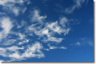
Cirrostratus clouds are high, thin clouds that form above
20,000 feet and are made mostly of ice crystals. They sometimes look like giant
feathers, horse tails, or curls of hair in the sky.
These clouds are pushed by the jet stream and can move at high speeds reaching
100 mph.
What do they indicate?
They indicate that a precipitation is likely within 24 hours.
Next Topic: Cirrus Clouds
Current conditions powered by WeatherAPI.com


