Weather Alert in Alaska
High Wind Warning issued March 14 at 2:03PM AKDT until March 15 at 10:00PM AKDT by NWS Juneau AK
AREAS AFFECTED: Prince of Wales Island
DESCRIPTION: ...STRONG LOW PRESSURE SYSTEM QUICKLY INCREASES WINDS SUNDAY... A storm force low pressure system pushes north into the gulf Sunday bringing strong winds toward the gulf coast and southern panhandle. There is high confidence that this low will slightly intensify as it moves just west of Baranof Island. The low pressure system will then move northwest settling in the northern gulf by Monday. * WHAT...East winds 20 to 30 mph with gusts up to 60 mph expected. * WHERE...Prince of Wales Island. * WHEN...From 1 PM to 10 PM AKDT Sunday. * IMPACTS...High winds will blow around unsecured objects and may damage property and cause power outages. Travel by land, sea, or air will be difficult. * ADDITIONAL DETAILS...Strongest winds are likely to remain around southern portions of Prince of Wales Island. These winds, combined with the expected snow, can create hazardous traveling conditions across interior roadways with visibilities one mile or less. Winds will increase Sunday morning with gusts of 40 to 50 mph leading up to and following the High Wind Warning.
INSTRUCTION: People are urged to secure vessels and loose objects that could be blown around or damaged by the wind. Report any damage to the National Weather Service by visiting weather.gov/Juneau/StormReports
Want more detail? Get the Complete 7 Day and Night Detailed Forecast!
Current U.S. National Radar--Current
The Current National Weather Radar is shown below with a UTC Time (subtract 5 hours from UTC to get Eastern Time).

National Weather Forecast--Current
The Current National Weather Forecast and National Weather Map are shown below.

National Weather Forecast for Tomorrow
Tomorrow National Weather Forecast and Tomorrow National Weather Map are show below.

North America Water Vapor (Moisture)
This map shows recent moisture content over North America. Bright and colored areas show high moisture (ie, clouds); brown indicates very little moisture present; black indicates no moisture.

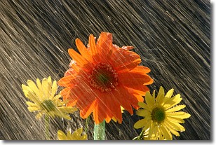
Weather Topic: What is Precipitation?
Home - Education - Precipitation - Precipitation
 Next Topic: Rain
Precipitation can refer to many different forms of water that
may fall from clouds. Precipitation occurs after a cloud has become saturated to
the point where its water particles are more dense than the air below the cloud.
In most cases, precipitation will reach the ground, but it is not uncommon for
precipitation to evaporate before it reaches the earth's surface.
When precipitation evaporates before it contacts the ground it is called Virga.
Graupel, hail, sleet, rain, drizzle, and snow are forms of precipitation, but fog
and mist are not considered precipitation because the water vapor which
constitutes them isn't dense enough to fall to the ground.
Next Topic: Rain
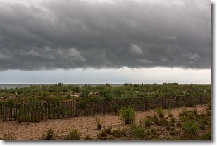
Weather Topic: What are Shelf Clouds?
Home - Education - Cloud Types - Shelf Clouds
 Next Topic: Sleet
A shelf cloud is similar to a wall cloud, but forms at the front
of a storm cloud, instead of at the rear, where wall clouds form.
A shelf cloud is caused by a series of events set into motion by the advancing
storm; first, cool air settles along the ground where precipitation has just fallen.
As the cool air is brought in, the warmer air is displaced, and rises above it,
because it is less dense. When the warmer air reaches the bottom of the storm cloud,
it begins to cool again, and the resulting condensation is a visible shelf cloud.
Next Topic: Sleet
Current conditions powered by WeatherAPI.com


