Weather Alert in Alaska
Wind Advisory issued March 14 at 2:03PM AKDT until March 16 at 1:00AM AKDT by NWS Juneau AK
AREAS AFFECTED: Western Kupreanof and Kuiu Island; Ketchikan Gateway Borough
DESCRIPTION: ...STRONG LOW PRESSURE SYSTEM QUICKLY INCREASES WINDS SUNDAY... A storm force low pressure system pushes north into the gulf Sunday bringing strong winds toward the gulf coast and southern panhandle. There is high confidence that this low will slightly intensify as it moves just west of Baranof Island. The low pressure system will then move northwest settling in the northern gulf by Monday. * WHAT...East winds 20 to 30 mph with gusts up to 55 mph expected. * WHERE...Western Kupreanof Island and Kuiu Island and Ketchikan Gateway Borough. * WHEN...From 1 PM Sunday to 1 AM AKDT Monday. * IMPACTS...Gusty winds could blow around unsecured objects. Use extra caution if traveling by land, sea, or air.
INSTRUCTION: Use extra caution when driving, especially if operating a high profile vehicle. Secure outdoor objects.
Want more detail? Get the Complete 7 Day and Night Detailed Forecast!
Current U.S. National Radar--Current
The Current National Weather Radar is shown below with a UTC Time (subtract 5 hours from UTC to get Eastern Time).

National Weather Forecast--Current
The Current National Weather Forecast and National Weather Map are shown below.

National Weather Forecast for Tomorrow
Tomorrow National Weather Forecast and Tomorrow National Weather Map are show below.

North America Water Vapor (Moisture)
This map shows recent moisture content over North America. Bright and colored areas show high moisture (ie, clouds); brown indicates very little moisture present; black indicates no moisture.

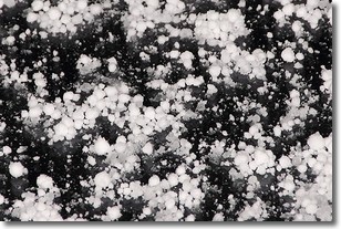
Weather Topic: What is Graupel?
Home - Education - Precipitation - Graupel
 Next Topic: Hail
Graupel is a form of precipitation that is created by atmospheric conditions
which cause supercooled water droplets to contact snow crystals and freeze to
their surface.
Sometimes known as soft hail or snow pellets, graupel is delicate and easily
destroyed by touch. Whereas hail usually falls during severe weather, graupel
doesn't require such conditions to form, and can form in mild precipitation
similar to situations which produce snowfall.
Next Topic: Hail
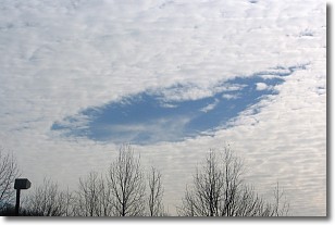
Weather Topic: What are Hole Punch Clouds?
Home - Education - Cloud Types - Hole Punch Clouds
 Next Topic: Mammatus Clouds
A hole punch cloud is an unusual occurrence when a disk-shaped
hole appears in a cirrostratus, cirrocumulus, or altocumulus cloud.
When part of the cloud forms ice crystals, water droplets in the surrounding area
of the cloud evaporate. The effect of this process produces a large elliptical
gap in the cloud. The hole punch cloud formation is rare, but it is not specific
to any geographic area.
Other names which have been used to describe this phenomena include fallstreak hole,
skypunch, and cloud hole.
Next Topic: Mammatus Clouds
Current conditions powered by WeatherAPI.com


