Weather Alert in South Carolina
Flash Flood Warning issued August 22 at 5:52PM EDT until August 22 at 9:00PM EDT by NWS Charleston SC
AREAS AFFECTED: Charleston, SC
DESCRIPTION: FFWCHS The National Weather Service in Charleston has extended the * Flash Flood Warning for... Charleston County in southeastern South Carolina... * Until 900 PM EDT. * At 552 PM EDT, Doppler radar indicated bands of moderate to locally heavy rainfall moving into Mount Pleasant, Isle of Palms and Sullivans Island. While additional rainfall should average less than 2 inches, the combination of an elevated incoming high tide and heavy rainfall should produce areas of additional flash flooding. The warning has been extended for this reason. HAZARD...Flash flooding caused by thunderstorms. SOURCE...Radar indicated. IMPACT...Flash flooding of small creeks and streams, urban areas, highways, streets and underpasses as well as other poor drainage and low-lying areas. * Some locations that will experience flash flooding include... Mount Pleasant, Isle Of Palms, Sullivan's Island, Mount Pleasant Towne Centre, Boone Hall Plantation, Sullivans Island, Seaside Farms, East Cooper Regional Medical Center, Hamlin Plantation and Snowden. This includes I-526 between mile markers 29 and 31.
INSTRUCTION: Turn around, don't drown when encountering flooded roads. Most flood deaths occur in vehicles. Flooding is likely in low-lying coastal areas where high tide will inhibit runoff of heavy rain.
Want more detail? Get the Complete 7 Day and Night Detailed Forecast!
Current U.S. National Radar--Current
The Current National Weather Radar is shown below with a UTC Time (subtract 5 hours from UTC to get Eastern Time).

National Weather Forecast--Current
The Current National Weather Forecast and National Weather Map are shown below.

National Weather Forecast for Tomorrow
Tomorrow National Weather Forecast and Tomorrow National Weather Map are show below.

North America Water Vapor (Moisture)
This map shows recent moisture content over North America. Bright and colored areas show high moisture (ie, clouds); brown indicates very little moisture present; black indicates no moisture.

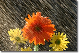
Weather Topic: What is Precipitation?
Home - Education - Precipitation - Precipitation
 Next Topic: Rain
Precipitation can refer to many different forms of water that
may fall from clouds. Precipitation occurs after a cloud has become saturated to
the point where its water particles are more dense than the air below the cloud.
In most cases, precipitation will reach the ground, but it is not uncommon for
precipitation to evaporate before it reaches the earth's surface.
When precipitation evaporates before it contacts the ground it is called Virga.
Graupel, hail, sleet, rain, drizzle, and snow are forms of precipitation, but fog
and mist are not considered precipitation because the water vapor which
constitutes them isn't dense enough to fall to the ground.
Next Topic: Rain
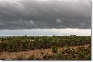
Weather Topic: What are Shelf Clouds?
Home - Education - Cloud Types - Shelf Clouds
 Next Topic: Sleet
A shelf cloud is similar to a wall cloud, but forms at the front
of a storm cloud, instead of at the rear, where wall clouds form.
A shelf cloud is caused by a series of events set into motion by the advancing
storm; first, cool air settles along the ground where precipitation has just fallen.
As the cool air is brought in, the warmer air is displaced, and rises above it,
because it is less dense. When the warmer air reaches the bottom of the storm cloud,
it begins to cool again, and the resulting condensation is a visible shelf cloud.
Next Topic: Sleet
Current conditions powered by WeatherAPI.com


