Weather Alert in California
Special Weather Statement issued July 29 at 5:44PM PDT by NWS San Francisco CA
AREAS AFFECTED: San Francisco; Coastal North Bay Including Point Reyes National Seashore; North Bay Interior Valleys; San Francisco Bay Shoreline; San Francisco Peninsula Coast; Northern Monterey Bay; Southern Monterey Bay and Big Sur Coast
DESCRIPTION: ...TSUNAMI WATCH IS IN EFFECTOR COASTAL AREAS FROM SONOMA COUNTY SOUTHWARD TO MONTEREY COUNTY INCLUDING THE BAY AREA COASTLINE... THE NATIONAL WEATHER SERVICE HAS ISSUED A TSUNAMI WATCH FOR COASTAL AREAS FROM SONOMA COUNTY SOUTHWARD TO MONTEREY COUNTY INCLUDING THE BAY AREA COASTLINE. IF YOU ARE LOCATED IN THIS COASTAL AREA, STAY ALERT FOR FURTHER UPDATES. AT 425 PM PACIFIC DAYLIGHT TIME ON JULY 29 AN EARTHQUAKE WITH PRELIMINARY MAGNITUDE OF 8.7 OCCURRED 80 MILES SOUTHEAST OF PETROPAVLOVSK KAMCHATKA. ESTIMATED ARRIVAL TIMES FOR THE FIRST IN THE SERIES OF TSUNAMI WAVES ARE AS FOLLOWS IN PACIFIC DAYLIGHT TIME. SAN FRANCISCO CALIFORNIA ON JULY 30 AT 1240 AM. ONCE AGAIN, THE NATIONAL WEATHER SERVICE HAS ISSUED A TSUNAMI WATCH FOR THE FOLLOWING LOCATIONS, COASTAL AREAS FROM SONOMA COUNTY SOUTHWARD TO MONTEREY COUNTY INCLUDING THE BAY AREA COASTLINE. IF YOU ARE LOCATED IN THIS COASTAL AREA, STAYALERT FOR FURTHER UPDATES. STAY TUNED TO YOUR LOCAL NEWS SOURCE AND NOAA WEATHER RADIO FOR FURTHER INFORMATION AND UPDATES.... * LOCAL IMPACTS...COASTAL AREAS FROM SONOMA COUNTY SOUTHWARD TO MONTEREY COUNTY INCLUDING THE BAY AREA COASTLINE * RECOMMENDED ACTIONS... For people in the watch area...If you are located in this coastal area, stay alert for further updates, as well as instructions from your local emergency officials. * FORECAST TSUNAMI START TIMES...San Francisco Bay, Monterey Bay, and Central Coast of California 1215 AM PDT on Jul 30 Tsunamis often arrive as a series of waves or surges which could be dangerous for many hours after the first wave arrival. The first tsunami wave or surge may not be the highest in the series. * FORECAST TSUNAMI DURATION... TSUNAMI WATCH iS UNIL FURTHER NOTICe * PRELIMINARY EARTHQUAKE INFORMATION... An earthquake occurred with a preliminary magnitude of 8.7. This product will be updated as new information becomes available. Stay tuned to your local news source and NOAA weather radio for further information and updates.
INSTRUCTION: N/A
Want more detail? Get the Complete 7 Day and Night Detailed Forecast!
Current U.S. National Radar--Current
The Current National Weather Radar is shown below with a UTC Time (subtract 5 hours from UTC to get Eastern Time).

National Weather Forecast--Current
The Current National Weather Forecast and National Weather Map are shown below.

National Weather Forecast for Tomorrow
Tomorrow National Weather Forecast and Tomorrow National Weather Map are show below.

North America Water Vapor (Moisture)
This map shows recent moisture content over North America. Bright and colored areas show high moisture (ie, clouds); brown indicates very little moisture present; black indicates no moisture.

Weather Topic: What is Graupel?
Home - Education - Precipitation - Graupel
 Next Topic: Hail
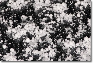
Graupel is a form of precipitation that is created by atmospheric conditions
which cause supercooled water droplets to contact snow crystals and freeze to
their surface.
Sometimes known as soft hail or snow pellets, graupel is delicate and easily
destroyed by touch. Whereas hail usually falls during severe weather, graupel
doesn't require such conditions to form, and can form in mild precipitation
similar to situations which produce snowfall.
Next Topic: Hail
Weather Topic: What are Hole Punch Clouds?
Home - Education - Cloud Types - Hole Punch Clouds
 Next Topic: Mammatus Clouds
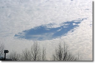
A hole punch cloud is an unusual occurrence when a disk-shaped
hole appears in a cirrostratus, cirrocumulus, or altocumulus cloud.
When part of the cloud forms ice crystals, water droplets in the surrounding area
of the cloud evaporate. The effect of this process produces a large elliptical
gap in the cloud. The hole punch cloud formation is rare, but it is not specific
to any geographic area.
Other names which have been used to describe this phenomena include fallstreak hole,
skypunch, and cloud hole.
Next Topic: Mammatus Clouds
Current conditions powered by WeatherAPI.com


