Weather Alert in Ohio
Flood Warning issued March 14 at 12:36PM EDT until March 16 at 8:00AM EDT by NWS Northern Indiana
AREAS AFFECTED: Williams, OH
DESCRIPTION: ...The Flood Warning is extended for the following rivers in Indiana...Ohio... Saint Joseph River Ohio near Newville affecting De Kalb, Defiance and Allen IN Counties. Saint Joseph River Ohio below Montpelier affecting Williams County. ...The Flood Warning continues for the following rivers in Ohio... Tiffin River at Stryker affecting Williams, Defiance and Fulton OH Counties. For the Saint Joseph River Ohio...including Montpelier, Newville... Moderate flooding is forecast. For the Tiffin River...including Stryker...Minor flooding is forecast. * WHAT...Moderate flooding is occurring and minor flooding is forecast. * WHERE...Saint Joseph River Ohio below Montpelier. * WHEN...Until Monday morning. * IMPACTS...At 13.0 feet, County Road K, one mile southwest of Montpelier begins to flood. Some flooding begins to affect the village of Pioneer. Significant low land and agricultural flooding occurs near the river. * ADDITIONAL DETAILS... - At 9:00 AM EDT Friday, March 13 the stage was 13.2 feet. - Recent Activity...The maximum river stage in the 24 hours ending at 9:00 AM EDT Friday was -9999.0 feet. - Forecast...The river is expected to fall below flood stage tomorrow morning and continue falling to 10.5 feet Thursday morning. - Flood stage is 12.0 feet. - http://www.weather.gov/safety/flood
INSTRUCTION: Turn around, don't drown when encountering flooded roads. Most flood deaths occur in vehicles. Detailed river forecasts and additional information can be found at www.weather.gov/iwx under Rivers and Lakes. The next statement will be issued Sunday morning at 645 AM EDT.
Want more detail? Get the Complete 7 Day and Night Detailed Forecast!
Current U.S. National Radar--Current
The Current National Weather Radar is shown below with a UTC Time (subtract 5 hours from UTC to get Eastern Time).

National Weather Forecast--Current
The Current National Weather Forecast and National Weather Map are shown below.

National Weather Forecast for Tomorrow
Tomorrow National Weather Forecast and Tomorrow National Weather Map are show below.

North America Water Vapor (Moisture)
This map shows recent moisture content over North America. Bright and colored areas show high moisture (ie, clouds); brown indicates very little moisture present; black indicates no moisture.

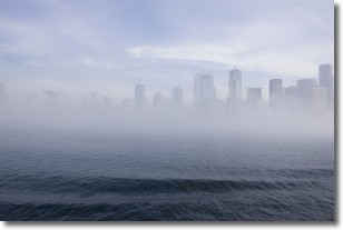
Weather Topic: What is Fog?
Home - Education - Cloud Types - Fog
 Next Topic: Fractus Clouds
Fog is technically a type of stratus cloud, which lies along the
ground and obscures visibility.
It is usually created when humidity in the air condenses into tiny water droplets.
Because of this, some places are more prone to foggy weather, such as regions
close to a body of water.
Fog is similar to mist; both are the appearance of water droplets suspended in
the air, but fog is the term applied to the condition when visibility is less than 1 km.
Next Topic: Fractus Clouds
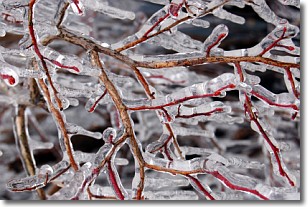
Weather Topic: What is Freezing Rain?
Home - Education - Precipitation - Freezing Rain
 Next Topic: Graupel
Freezing rain is a condition where precipitation which has fallen in the form of
water droplets reaches temperatures which are below freezing and freezes upon
coming into contact
with surface objects. The result of this precipitation is a glaze of ice which
can be damaging to plants and man-made structures. A severe onset of freezing
rain which results in a very thick glaze of ice is known as an ice storm.
Next Topic: Graupel
Current conditions powered by WeatherAPI.com


