Weather Alert in Ohio
Flood Warning issued March 14 at 12:36PM EDT by NWS Northern Indiana
AREAS AFFECTED: Defiance, OH; Fulton, OH; Williams, OH
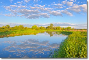
DESCRIPTION: ...The Flood Warning is extended for the following rivers in Indiana...Ohio... Saint Joseph River Ohio near Newville affecting De Kalb, Defiance and Allen IN Counties. Saint Joseph River Ohio below Montpelier affecting Williams County. ...The Flood Warning continues for the following rivers in Ohio... Tiffin River at Stryker affecting Williams, Defiance and Fulton OH Counties. For the Saint Joseph River Ohio...including Montpelier, Newville... Moderate flooding is forecast. For the Tiffin River...including Stryker...Minor flooding is forecast. * WHAT...Minor flooding is occurring and minor flooding is forecast. * WHERE...Tiffin River at Stryker. * WHEN...Until further notice. * IMPACTS...At 15.0 feet, Several rural buildings flood and flooding begins to affect residents in the village of Stryker. Many roads become impassible. * ADDITIONAL DETAILS... - At 11:00 AM EDT Saturday the stage was 14.5 feet. - Recent Activity...The maximum river stage in the 24 hours ending at 11:00 AM EDT Saturday was 15.4 feet. - Forecast...The river is expected to fall to 11.7 feet Thursday morning. - Flood stage is 11.0 feet. - http://www.weather.gov/safety/flood
INSTRUCTION: Turn around, don't drown when encountering flooded roads. Most flood deaths occur in vehicles. Detailed river forecasts and additional information can be found at www.weather.gov/iwx under Rivers and Lakes. The next statement will be issued Sunday morning at 645 AM EDT.
Want more detail? Get the Complete 7 Day and Night Detailed Forecast!
Current U.S. National Radar--Current
The Current National Weather Radar is shown below with a UTC Time (subtract 5 hours from UTC to get Eastern Time).

National Weather Forecast--Current
The Current National Weather Forecast and National Weather Map are shown below.

National Weather Forecast for Tomorrow
Tomorrow National Weather Forecast and Tomorrow National Weather Map are show below.

North America Water Vapor (Moisture)
This map shows recent moisture content over North America. Bright and colored areas show high moisture (ie, clouds); brown indicates very little moisture present; black indicates no moisture.

Weather Topic: What are Stratocumulus Clouds?
Home - Education - Cloud Types - Stratocumulus Clouds
 Next Topic: Stratus Clouds
Stratocumulus clouds are similar to altocumulus clouds in their
fluffy appearance, but have a slightly darker shade due to their additional mass.
A good way to distinguish the two cloud types is to hold your hand out and measure
the size of an individual cloud; if it is the size of your thumb it is generally
an altocumulus cloud, if it is the size of your hand it is generally a
stratocumulus cloud.
It is uncommon for stratocumulus clouds to produce precipitation, but if they do
it is usually a light rain or snow.
Next Topic: Stratus Clouds
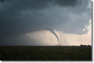
Weather Topic: What are Wall Clouds?
Home - Education - Cloud Types - Wall Clouds
 Next Topic: Altocumulus Clouds
A wall cloud forms underneath the base of a cumulonimbus cloud,
and can be a hotbed for deadly tornadoes.
Wall clouds are formed by air flowing into the cumulonimbus clouds, which can
result in the wall cloud descending from the base of the cumulonimbus cloud, or
rising fractus clouds which join to the base of the storm cloud as the wall cloud
takes shape.
Wall clouds can be very large, and in the Northern Hemisphere they generally
form at the southern edge of cumulonimbus clouds.
Next Topic: Altocumulus Clouds
Current conditions powered by WeatherAPI.com


