Weather Alert in Idaho
Hydrologic Outlook issued August 24 at 1:57PM MDT by NWS Boise ID
AREAS AFFECTED: Ada, ID; Adams, ID; Boise, ID; Camas, ID; Canyon, ID; Elmore, ID; Gem, ID; Gooding, ID; Jerome, ID; Owyhee, ID; Payette, ID; Twin Falls, ID; Valley, ID; Washington, ID; Baker, OR; Harney, OR; Malheur, OR
DESCRIPTION: ESFBOI A push of monsoonal moisture will bring several days of showers and thunderstorms to the region. Abnormally high moisture will allow for widespread heavy rain accumulation, leading to an increased threat of flash flooding. Tuesday and Wednesday currently look to have the best chance for heavy rain, especially in southeast Oregon, near the ID-NV border, and high terrain in southwest Idaho. Conditions will likely dry out considerably by the end of the week. Burn scars and steep and rocky terrain are at the most risk for flash flooding. The Wapiti Fire burn scar near Grandjean, ID, the Durkee Fire burn scar near Ironside, OR, and the Lava Fire burn scar near Cascade, ID are of particular concern for flash flooding. Recent fires also are vulnerable to flash flooding impacts. Please be aware of impacts in these areas and have multiple ways to receive flash flood warnings. Consider alternate plans if recreating near these areas.
INSTRUCTION: N/A
Want more detail? Get the Complete 7 Day and Night Detailed Forecast!
Current U.S. National Radar--Current
The Current National Weather Radar is shown below with a UTC Time (subtract 5 hours from UTC to get Eastern Time).

National Weather Forecast--Current
The Current National Weather Forecast and National Weather Map are shown below.

National Weather Forecast for Tomorrow
Tomorrow National Weather Forecast and Tomorrow National Weather Map are show below.

North America Water Vapor (Moisture)
This map shows recent moisture content over North America. Bright and colored areas show high moisture (ie, clouds); brown indicates very little moisture present; black indicates no moisture.

Weather Topic: What is Rain?
Home - Education - Precipitation - Rain
 Next Topic: Shelf Clouds
Precipitation in the form of water droplets is called rain.
Rain generally has a tendency to fall with less intensity over a greater period
of time, and when rainfall is more severe it is usually less sustained.
Rain is the most common form of precipitation and happens with greater frequency
depending on the season and regional influences. Cities have been shown to have
an observable effect on rainfall, due to an effect called the urban heat island.
Compared to upwind, monthly rainfall between twenty and forty miles downwind of
cities is 30% greater.
Next Topic: Shelf Clouds
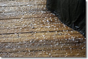
Weather Topic: What is Sleet?
Home - Education - Precipitation - Sleet
 Next Topic: Snow
Sleet is a form of precipitation in which small ice pellets are the primary
components. These ice pellets are smaller and more translucent than hailstones,
and harder than graupel. Sleet is caused by specific atmospheric conditions and
therefore typically doesn't last for extended periods of time.
The condition which leads to sleet formation requires a warmer body of air to be
wedged in between two sub-freezing bodies of air. When snow falls through a warmer
layer of air it melts, and as it falls through the next sub-freezing body of air
it freezes again, forming ice pellets known as sleet. In some cases, water
droplets don't have time to freeze before reaching the surface and the result is
freezing rain.
Next Topic: Snow
Current conditions powered by WeatherAPI.com


